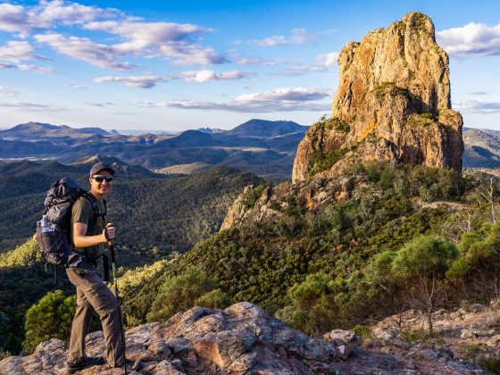
The Asgard Swamp Trail is one of the lesser-known hikes, yet it offers some of the most stunning viewpoints in the entire Blue Mountains, such as Thor Head and Asgard Head.
Beyond its epic views, this trail also provides the unique chance to explore an abandoned coal mine from 1880 and a historic Kiln at the Asgard Mine, making it an unforgettable adventure.
Another great thing about this trail is that you’ll get to explore the beautiful swampy areas up on the Asgard Plateau and all the side trails I’ll discuss require no lengthy or strenuous climbs to reach the viewpoints.
If this sounds appealing, read further for all the details to get ready for this unique hike in the Upper Blue Mountains.
How To Get To Asgard Swamp Trail
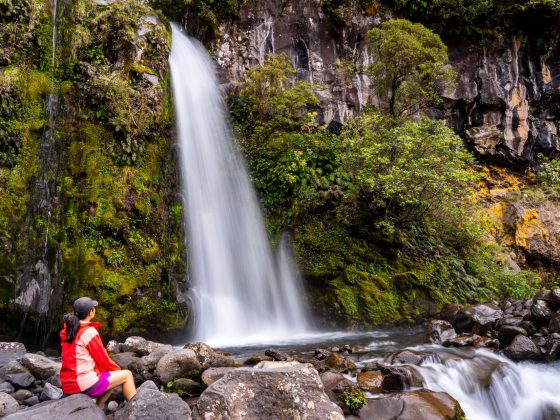
The Asgard Swamp Track begins northeast of Mount Victoria town, about a 2-hour drive from Sydney, covering a distance of around 124 kilometres.
To get there, exit the Great Western Highway (A32) and follow the unsealed Victoria Falls Road for around 4 kilometres. The road is mostly in good condition and can be driven with a 2WD vehicle despite a few potholes.
When you’re ready to head out, set your GPS coordinates to this spot along the Victoria Falls Rd.

There is no designated parking area, but you’ll find a few spots near the fire trail gate. You could also park in few other spots along the Victoria Falls Road.
Asgard Swamp Trail Overview
The official board at the trailhead indicates that there are only two trails here: Asgard Swamp and Asgard Mine.
However, there are few additional trails in this area, and the trails to Thor Head and Asgard Head are unofficial and unmarked.
Despite their unofficial status, they are easy to locate and follow (although they are slightly overgrown, so wearing long pants is recommended).
With that in mind, this article will focus on 4 side trails branching off from the main Asgard Swamp Track:
- Asgard Swamp
- Thor Head
- Asgard Mine
- Asgard Head

Now, let’s have a look at the combined trail stats for these 4 tracks:
- Distance: 8.7 km return
- Time: Half day
- Elevation Gain: 288m
- Difficulty: Moderate to Hard (unmarked trails, steep and unfenced cliff edges)

Asgard Swamp Trail
It’s worth noting at the outset of this article that 70% of this route requires walking along the mostly exposed Asgard Swamp Fire Trail.
But don’t let that discourage you, as the views and ambiance along this path are truly enjoyable.
Rest assured that once you reach the last 3 side trails, you’ll come to see that walking along the fire trail, often frowned upon by hikers, was actually worth the effort.
The trek starts as you make your way around the gate and onto the fire trail, descending for approximately 1km until you come to a section of the trail featuring scenic rocky outcrops along the left side.

After covering about 1.4 kilometers, the fire trail passes through a swampy portion along Asgard Brook, featuring a wooden plank to cross the wet section.

After about 2.3km, the track eventually reaches the Asgard Swamp.
However, there are no signs indicating the side trail to the swamp, so it’s important to keep your eyes peeled and watch for a landmark to your left called Pagoda Rock (or Pyramid Rock), which is also an informal campsite.

You can climb on top the Pagoda Rock to get a better view of the swamp, and there’s a trail running through the left side of the swamp that seems to lead to Valhalla Head.

Thor Head
The side trail to Thor Head is located approximately 300m from the trail to Asgard Swamp, so be sure to keep an eye out for the small path on your left.
As you make your way up the gently ascending trail, Thor Head will soon come into view directly in front of you.
Before heading directly towards Thor Head, take a moment to appreciate the magnificent, unobstructed views of the Grose Valley from a large rock platform.


The final stretch of the trail leading to Thor Head is somewhat overgrown and steeper than the previous section.
However, after a few minutes, you should be right at the top of Thor Head, where you can explore multiple viewpoints and admire unique rock formations below you.


I decided to grab a quick lunch here and found a nice spot at the highest point of Thor Head. There was a rock that looked just like a chair, so I thought it would be a perfect place to rest for a bit.

Asgard Mine
After returning to the fire trail, continue for another 250m. You’ll come across the beginning of the trail to Asgard Mine on your left, marked by a signpost, so you won’t miss it.

The mine is just 350m down a fairly steep, but not overly challenging trail that takes you past several large rock overhangs.
Soon enough, you’ll find yourself at the entrance to the Asgard Mine, marked by a yellow sign warning of low headroom and a slippery surface.

The mine is a short prospecting tunnel driven horizontally into the coal seam, known as the Katoomba Seam, and extends only about 25-35 metres into the cliff line.
It is quite stable and is believed to have been constructed in the 1880s as one of six prospecting tunnels in the area.
Although a seam of coal was found in the tunnel, it wasn’t of high enough quality to justify commercial mining.

Asgard Kiln
Once you exit the mine and follow the track to its end, you’ll find a kiln for producing coke, although it appears to have never been fired.
Coke is a grey, hard, porous coal-based fuel with high carbon content. The industrial production of coke from coal is called coking.

The kiln measures around 4 metres in length and 2 metres in height, most likely dating back to around 1908 when a tramway to the site was proposed.

Both Asgard Mine and the charming kiln, appearing to be embedded in the sandstone cliff wall, offer visually interesting spots for photographers, making it worth visiting solely for this purpose.
Asgard Head
When you’re done exploring the mine and kiln, head back to the main fire trail, turn left, and follow it to the end where you’ll find the Asgard Head viewpoint.
It’s just a quick 600m walk from the Asgard Mine junction to Asgard Head, despite the trail being slightly overgrown, it’s easy to navigate.
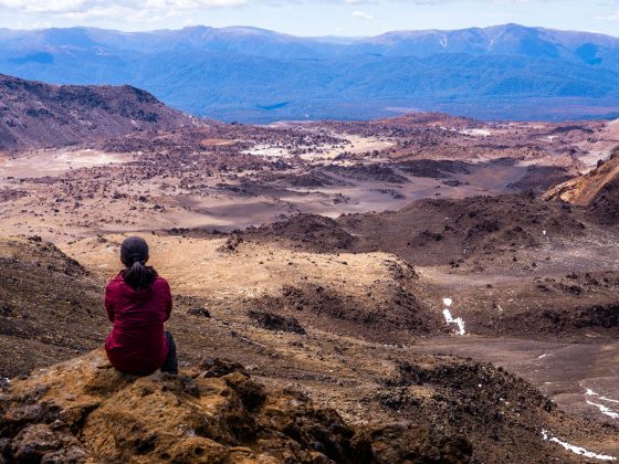
When you finally arrive at the Asgard Head, prepare to be amazed by the huge vertical drop and the stunning views that sweep across the Grose Valley from this spot.

From here you’ll be able to see Victoria Falls in the distance, with Dalpura Head to your left and Burra Korain Head to your right, making it one of the best lookout spots in the Blue Mountains!
With the day nearing its end, I decided to climb a bit higher onto a shield-shaped, rocky platform to soak in the sunset illuminating the cliffs surrounding the Grose Valley.


To wrap it up, the Asgard Swamp Track offers an unforgettable hiking adventure, with its impressive views and opportunities to explore historic sites like the mine and kiln, making it worth the visit.
Found it Helpful? Pin it For Later

Frequently Asked Questions (FAQs):
How long does the trail take?
- Few hours or half-day
What about signage and trail quality?
- As of writing this post, the only trail with signs is Asgard Mine, while the other three trails are unmarked; however, they are relatively easy to find
How difficult are the trails?
- Moderate to hard depending on your fitness level
What essentials should I carry?
- Torch for Asgard Mine, plenty of water, snacks, hat and a sunscreen
Is the trail wheelchair accessible?
- No
When is the best time to visit?
- I would start early in the morning on a hot, summer day
Is there phone service?
- Limited
Can I bring my dog?
- Pets and domestic animals (other than certified assistance animals) are not permitted