Trek Waves Trek Waves
  • TRAVEL DESTINATIONS
    • ALL DESTINATIONS
    • AUSTRALIA
      • BLUE MOUNTAINS
      • CAPERTEE NATIONAL PARK
      • GARDENS OF STONE
      • GRAMPIANS NATIONAL PARK
      • MOUNT BUFFALO
      • ROYAL NATIONAL PARK
      • TASMANIA
    • ICELAND
    • ITALY
  • ABOUT
  • CONTACT
Trek Waves Trek Waves Trek Waves
  • TRAVEL DESTINATIONS
    • ALL DESTINATIONS
    • AUSTRALIA
      • BLUE MOUNTAINS
      • CAPERTEE NATIONAL PARK
      • GARDENS OF STONE
      • GRAMPIANS NATIONAL PARK
      • MOUNT BUFFALO
      • ROYAL NATIONAL PARK
      • TASMANIA
    • ICELAND
    • ITALY
  • ABOUT
  • CONTACT
Butterbox Point Blue Mountains Hike
  • Australia
  • Blue Mountains National Park

Butterbox Point Trail Guide | Scenic Hike in Blue Mountains

  • September 30, 2024
  • Pavo TREKS
Total
2
Shares
Share 0
Tweet 0
Pin it 2
Share 0

Butterbox Point in the Blue Mountains marks the final trail along Mount Hay Road, and despite being shorter than Lockleys Pylon and Fortress Ridge, it delivers breathtaking views of the Grose Valley, Mount Hay, Mount Banks, and the towering Walford Wall.

Here you will be treated to a landscape brimming with natural beauty, from rare hanging swamps to surreal geological formations shaped by ironstone erosion.

The trail starts off gently, but as you progress toward Butterbox Point, it narrows and becomes more thrilling, taking you along cliff edges that offer spectacular views.

I’ll cover everything you need to know to prepare you for this scenic hike.

Table of Contents Hide
  1. How To Get To Butterbox Point
    1. Mount Hay and Butterbox Point Carpark
  2. Butterbox Point Trail Overview
  3. Trail To Butterbox Point
  4. Trail To Butterbox Canyon
  5. Trail to Mount Hay
  6. Found it Helpful? Pin it For Later
  7. Frequently Asked Questions (FAQs):

How To Get To Butterbox Point

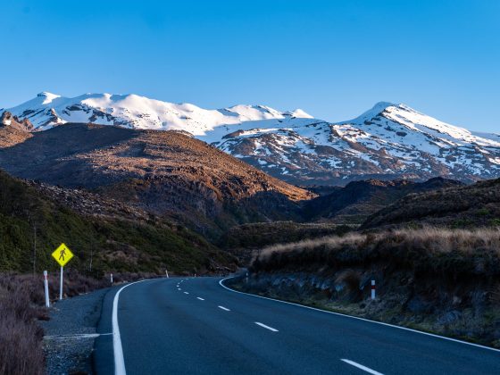
The Butterbox Point track begins off Mount Hay Road, just north of Leura. You can find the exact location by clicking here for the Google Maps pin.

You’ll be driving 12.7km (approximately 30 mins) on an unsealed fire road. While a 4WD isn’t required, the road does have a few bumps and potholes.

I drove my small 2WD car without any problems, and it looks like the road has been graded recently, making the drive much smoother compared to a few months ago.

Mount Hay and Butterbox Point Carpark

There’s a good-sized parking area at the end of Mount Hay Road offering spectacular views and a helpful information board right at the trailhead.

Butterbox Point Trailhead Blue Mountains
Butterbox Point Trailhead
Butterbox Point Mount Hay Car Park Blue Mountains
Mount Hay and Butterbox Point Carpark

Butterbox Point Trail Overview

At the trailhead map, you’ll see there are three trails to choose from:

  • Butterbox Point hiking trail
  • Mount Hay Summit hiking trail
  • Butterbox Canyon (or Mt Hay Canyon)
Butterbox Point Trail Information Board
Butterbox Point Trailhead Information Board

In this article, I’ll focus on the first two trails, leaving out Butterbox Canyon since it requires abseiling equipment to navigate the 40m descent over a chockstone and through a waterfall into a plunge pool.

Here are the key trail stats for both of these trails combined:

  • Start & Finish: Mount Hay & Butterbox Point Carpark
  • Distance: 5.5 km return
  • Elevation Gain: 252 m
  • Time: 2-3 hours
  • Difficulty: Medium
  • Location: Blue Mountains, NSW, Australia
butterbox point mount hay trail map blue mountains
Butterbox Point & Mount Hay Trail Map

Trail To Butterbox Point

Beginning at the Mount Hay and Butterbox Point Carpark, the trail immediately immerses you in the stunning bushland and sandstone cliffs characteristic of the Blue Mountains.

One of the most remarkable features along the first part of the trail is the Hanging Swamps, an endangered ecological community unique to this region.

These swamps are perched along steep slopes, fed by slow-draining groundwater. They play a crucial role in supporting rare species like the Blue Mountains Water Skink and Giant Dragonfly.

As you hike along the ridge, you’ll notice the swamp vegetation—grasses, sedges, and mosses—that thrive in this fragile environment, providing an important habitat for endangered fauna.

Butterbox Point Hanging Swamps
Butterbox point Hanging Swamps

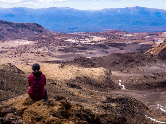
The surrounding area is rich in ironstone formations, created through natural erosion. These geological structures, visible as you approach Butterbox Point, are particularly striking.

Razor-sharp, wave-like stone patterns form an almost alien-like landscape, with some areas resembling amphitheaters or fossilized ripples frozen in time.

Butterbox Point Blue Mountains ironstone rock formations
First Part Of the Butterbox Point Trail

These surreal formations result from Liesegang Rings, a process where iron precipitates and hardens in concentric layers over thousands of years.

Butterbox Point Blue Mountains Hiking 1
Unique Rock Formations On the Way to Butterbox Point

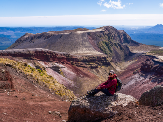
As you reach the final stretch of the trail, you’ll be greeted with a stunning view of Butterbox Point, resembling a small castle surrounded by a circular trail, with Mount Banks looming to the right.

Butterbox Point Blue Mountains
Final Part Of the Butterbox Point Trail

On the eastern side of Butterbox Point, there’s a trail that leads you an incredible viewing platform at the top.

I recommend taking this detour first, as it offers an amazing viewpoint overlooking the Grose Valley and gives you your first peek into Butterbox Canyon from above.

butterbox point summit blue mountains
View From The Butterbox POint ‘Summit’
mount banks and grose valley from butterbox point
Mount Banks And Grose Valley View From ButterBox Point ‘Summit’

Trail To Butterbox Canyon

As you follow the loop trail along Mount Hay Wall toward Butterbox Canyon, you can descend further down to a second viewing platform, bringing you closer to the imposing cliff faces and offering a deeper view into the canyon itself.

Although the direct access to the canyon is restricted to protect the endangered swamp nearby, those with the right experience and gear can still venture further down the trail.

Butterbox canyon viewing platform Blue Mountains
Butterbox Canyon Final ‘Viewing Platform’

Trail to Mount Hay

For those seeking an extra challenge, you can extend the hike to include Mount Hay Summit. If this sounds appealing, retrace your steps back to the car park and follow the signs pointing toward Mount Hay.

The first section of the trail is well-marked and undergoing upgrades at the time of writing. However, as you progress, the trail becomes much more demanding.

The second part involves rock scrambling and, at times, is heavily overgrown, making the path difficult to follow.

Mount Hay Summit Trail Blue Mountains
Butterbox Point View From MOunt Hay Summit Trail

With volcanic origins stretching back over 17 million years, Mount Hay provides an interesting geological contrast to the surrounding sedimentary landscapes.

Though the summit is simply a pile of rocks with no views due to dense overgrowth, I found the hike through the purple-hued Indigofera Australis forest during spring a rewarding experience nonetheless.

Mount Hay Summit Blue Mountains
Mount Hay Summit

Found it Helpful? Pin it For Later

Butterbox Point Trail Blue Mountains Hike

Frequently Asked Questions (FAQs):

How long does the trail take?

  • Few hours

What about signage and trail quality?

  • There are multiple signs along the trail

How difficult are the trails?

  • Easy / Moderate (Mount Hay is harder than Butterbox Point)

What essentials should I carry?

  • Plenty of water, snacks, hat and a sunscreen

Is the trail wheelchair accessible?

  • No

When is the best time to visit?

  • I would start early in the morning on a hot, summer day

Is there a phone service?

  • Yes

Can I bring my dog?

  • Pets and domestic animals (other than certified assistance animals) are not permitted
Post Views: 371
Total
2
Shares
Share 0
Tweet 0
Pin it 2
Share 0
Pavo TREKS

Polish wanderer and founder of Trek Waves living +15 years in Sydney, Australia, with a love for hiking, trail exploration, mountain biking, photography, videography, and the insights of a geography master's.

You May Also Like
Blue Mountains Best Waterfall Hikes
View Post
  • Australia
  • Blue Mountains National Park

40 MUST-SEE Waterfalls in Blue Mountains: A Complete Guide

  • Pavo TREKS
  • July 21, 2025
10 Best Day Hikes in Blue Mountains Australia
View Post
  • Australia
  • Blue Mountains National Park

20 BEST Hikes in Blue Mountains National Park

  • Pavo TREKS
  • June 11, 2025
Top 5 Best Lookouts in Mount Kaputar National Park
View Post
  • Australia

5 BEST Lookouts with Epic Views in Mount Kaputar National Park

  • Pavo TREKS
  • May 7, 2025
Bruny Island 1 Day Tour Travel Guide and Itinerary
View Post
  • Australia
  • Tasmania

Bruny Island in 1 DAY: Top Attractions, Walks & Food Stops

  • Pavo TREKS
  • March 25, 2025
Wineglass Bay Beach Hike Guide Tasmania Freycinet National Park
View Post
  • Australia
  • Tasmania

Wineglass Bay Hike Guide | Freycinet National Park, Tasmania

  • Pavo TREKS
  • March 23, 2025
Nelson Falls Rainforest Walk Guide in Tasmania
View Post
  • Australia
  • Tasmania

Nelson Falls Rainforest Walk | Tasmania’s West Coast

  • Pavo TREKS
  • March 22, 2025
Russell Falls Walk Mt Field National Park Tasmania
View Post
  • Australia
  • Tasmania

Russell Falls: The Crown Jewel of Mt Field National Park

  • Pavo TREKS
  • March 16, 2025
three falls circuit walk mount field national park tasmania
View Post
  • Australia
  • Tasmania

Three Falls Circuit Walk | Mt Field National Park

  • Pavo TREKS
  • March 14, 2025
Tarn Shelf Circuit Walk Mount Field National Park
View Post
  • Australia
  • Tasmania

Tarn Shelf Circuit: A Hiker’s Dream in Mount Field National Park

  • Pavo TREKS
  • March 9, 2025

Leave a Reply Cancel reply

Your email address will not be published. Required fields are marked *

Author
Pavo TREKS
Polish wanderer and founder of Trek Waves living +15 years in Sydney, Australia, with a love for hiking, trail exploration, mountain biking, photography, videography, and the insights of a geography master's.
Buy me a coffee
Keep in Touch
YouTube 873 Subscribers
Pinterest 5K Views
Instagram 0
Featured Posts
  • Blue Mountains Best Waterfall Hikes
    40 MUST-SEE Waterfalls in Blue Mountains: A Complete Guide
  • 10 Best Day Hikes in Blue Mountains Australia
    20 BEST Hikes in Blue Mountains National Park
  • Top 5 Best Lookouts in Mount Kaputar National Park
    5 BEST Lookouts with Epic Views in Mount Kaputar National Park
  • Bruny Island 1 Day Tour Travel Guide and Itinerary
    Bruny Island in 1 DAY: Top Attractions, Walks & Food Stops
  • Wineglass Bay Beach Hike Guide Tasmania Freycinet National Park
    Wineglass Bay Hike Guide | Freycinet National Park, Tasmania
  • Nelson Falls Rainforest Walk Guide in Tasmania
    Nelson Falls Rainforest Walk | Tasmania’s West Coast
  • Russell Falls Walk Mt Field National Park Tasmania
    Russell Falls: The Crown Jewel of Mt Field National Park

Latest Posts

  • 40 MUST-SEE Waterfalls in Blue Mountains: A Complete Guide
  • 20 BEST Hikes in Blue Mountains National Park
  • 5 BEST Lookouts with Epic Views in Mount Kaputar National Park
  • Bruny Island in 1 DAY: Top Attractions, Walks & Food Stops
  • Wineglass Bay Hike Guide | Freycinet National Park, Tasmania
Trek Waves Trek Waves
  • TRAVEL DESTINATIONS
  • ABOUT
  • CONTACT
Endless Waves of Adventure Begin with One Trek

Input your search keywords and press Enter.