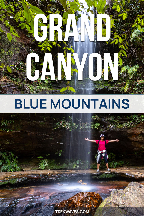
If you’re looking for an incredible hiking trail close to Sydney, I’ve got the perfect gem for you: the legendary Grand Canyon Walk in the Blue Mountains.
This trail definitely stands out from the rest of the walks in Blue Mountains; it is a gateway to a UNESCO World Heritage-listed haven, a verdant rainforest realm teeming with over 100 million years of history.
Situated near Blackheath, the Grand Canyon Walk takes you through a landscape filled with towering sandstone walls, perennial waterfalls, and a rich diversity of native plant life.
This iconic loop track has been a go-to choice for explorers since 1907 and continues to be a top pick among hiking trails in the Blue Mountains, Australia.
As a big fan of this hike, I’m excited to show you why the Grand Canyon trail is so special.
Where To Start Grand Canyon Walk
When setting out on the Grand Canyon Walking Track, choosing the right starting point is key.
You have three primary car parks to kick off your Grand Canyon adventure: Evans Lookout Car Park, Grand Canyon Car Park, and Neates Glen Car Park.
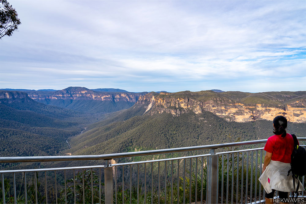
1. Evans Lookout Car Park is positioned at one of the most iconic viewpoints in the Blue Mountains. It offers stunning panoramic views of the Grose Valley, Bridal Veil Falls, and the surrounding cliffs.
Starting here provides an immediate taste of the mesmerising beauty of the Blue Mountains. However, some hikers prefer to save this beautiful view for the end of their hike.
2. Grand Canyon Car Park is another popular starting point. It offers easy access to the trail, giving you the flexibility to choose between a clockwise or counter-clockwise direction for your hike.
3. Neates Glen Car Park is my recommended starting point for a particular reason. Beginning your hike from Neates Glen lets you take on the trail in a counter-clockwise direction.
Starting your hike at Neates Glen and choosing the counter-clockwise path presents a smoother climb towards the trek’s conclusion. The ascent to Glen Neates Car Park tends to be more strenuous than reaching Evans Lookout.
In simpler terms, this route conserves your energy, giving your legs a lighter load. Plus, it ensures a stunning reward—the breathtaking view from Evans Lookout—as the crowning moment of your Grand Canyon Walking track adventure.
Grand Canyon Walking Track Stats & Map
Before you head out to explore the Grand Canyon Walk, it’s important to get familiar with a map of the terrain and understand some key facts about the hike.
- Distance: The Grand Canyon Walk is approximately 5.8 kilometers (about 3.6 miles) long.
- Duration: On average, it takes hikers about 3 to 4 hours to complete the entire loop, depending on their pace and the time spent enjoying the scenery.
- Elevation Gain: Expect to climb 300 meters and descend 285 meters as you explore this trail.
- Difficulty: This walk is considered moderately challenging due to rocky paths, steep descents, and staircases.


How to Get to Grand Canyon Walk in Blue Mountains?
The Grand Canyon Walk in the Blue Mountains is most conveniently accessed by car. However, public transport is also an option. Here’s how to get there:
By Car
- Evans Lookout Car Park: Set your GPS or navigation app to Evans Lookout Road, Blackheath, New South Wales, 2785 or click this link.
- Grand Canyon Car Park: Input Grand Canyon Car Park, Blackheath, New South Wales, 2785 into your GPS or click this link.
- Neates Glen Car Park: Type Neates Glen Parking Area, Blackheath, New South Wales, 2785 into your GPS or click this link.
By Public Transport
While car travel is recommended, you can also reach the Grand Canyon Walk via public transport. You can take a train from Sydney to the Blue Mountains and get off in Katoomba or Blackheath.
Be aware that there’s an approximately 4.2-kilometer (about 2.6 miles) walking distance from Blackheath train station to the nearest starting point of the hike (Neates Glen Car Park).
Another option for those without a car is a public bus 698 (loop service) from Carrington Hotel in Katoomba. It will take you to 275 Evans Lookout Rd in around 16 minutes (14 stops). From the bus stop you’ll need to walk an additional 550m to the Neates Glen Parking area, where the hike begins.
The most effective method for planning your trek without the car would be to use the Transport NSW Trip Planner.
This will guarantee that you have access to the most up-to-date timetable and are informed about any potential alerts.
Heading Down Into The Grand Canyon
If you’ve chosen the anti-clockwise route (great choice!), you’ll easily spot the start of the trek just behind the car park.
At the beginning, the trail slopes downward, and some sections can be quite steep and narrow. Expect to step aside occasionally, as it’s common to cross paths with fellow hikers, especially on bustling days.
As you delve deeper into the canyon, the scenery gradually transforms into a greener and more lush environment, with occasional patches of moisture. After about 550 meters, you’ll have descended nearly 140 meters, unveiling a picturesque change in the landscape.
This part of the hike treats you to charming sights of small waterfalls and an abundance of ferns adorning the trail, creating a delightful and vibrant atmosphere.

Reaching The Rotunda
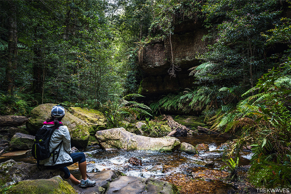
After hiking for approximately 750 meters, you’ll arrive at a serene spot known as the Rotunda. The Rotunda is a unique feature along Greaves Creek, where nature has sculpted a striking overhang above a sandy beach nestled within the heart of the Grand Canyon.
This picturesque location is an ideal place to take a break after the steep descent, enjoy a refreshing snack, and unwind, particularly when the sun is shining brightly, and the temperature is on the rise.

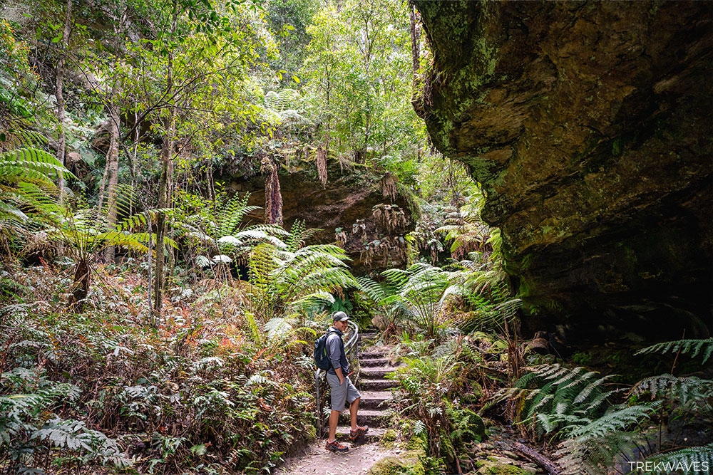
Rockfall Tunnel and First Waterfall
Just past the Rotunda, there’s a pitch-black cave and the trail leads you right into it. But don’t worry, the darkness doesn’t last long.
After just a few steps, you’ll see the light at the end. This tunnel was created due to a rockfall in the past, adding an extra element of excitement to your trek.
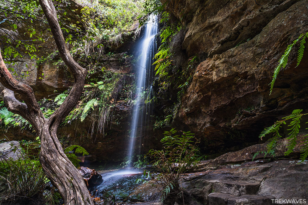
Once you’ve made it through the tunnel and descended a bit further, you’ll come across a charming waterfall. I couldn’t find the waterfall’s name, but it’s my absolute favorite spot on the entire trail.
You’ll discover some flat rocks nearby, perfect for taking a break and enjoying the beautiful scenery.
The path actually runs behind the waterfall, so expect to feel a light mist on your face as you walk through. On a scorching hot day, it’s the ideal spot to have a refreshing, natural shower courtesy of the waterfall.

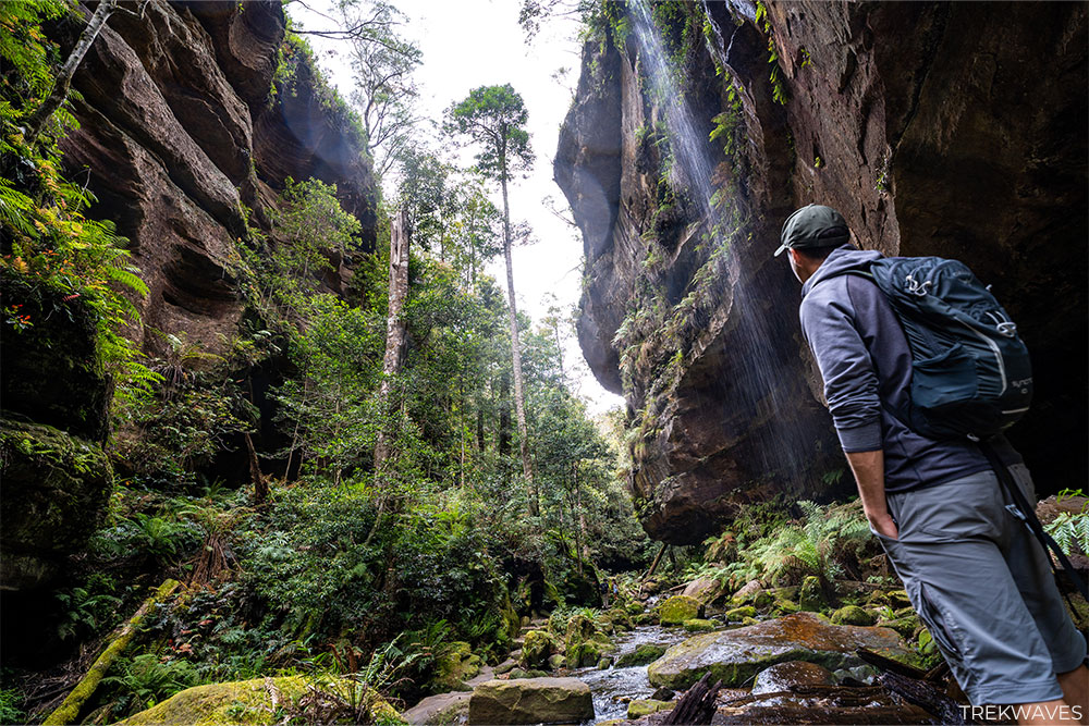
Along The Grand Canyon Floor
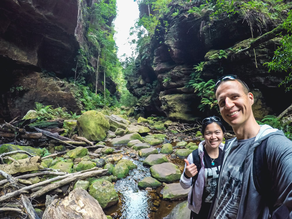
As you progress along the trail, covering a few kilometers of your journey, you’ll eventually find yourself descending into the heart of the canyon.
This is where the adventure truly comes to life, thanks to a network of stepping stone crossings that crisscross over the creek.
This particular stretch of the trail stands out as the ultimate highlight of the entire walk. The combination of the gushing waterway, the resonating sounds of nature, and the vibrant birdlife, all framed by the towering canyon walls, creates a breathtaking and immersive experience.
It’s a place where the very essence of the canyon seems magnified, enveloping you in its beauty and grandeur.
As you venture deeper, you’ll traverse charming wooden bridges and winding pathways that meander through the heart of the rainforest.
The proximity to the flowing water and the harmonious symphony of birdcalls form a unique and captivating backdrop.
If there has been recent rainfall, the canyon treats you to a spectacle of numerous small waterfalls cascading down its walls. This natural display enhances the allure of the place even further, and if you’re willing to embrace a bit of mud, taking this hike shortly after rain is highly recommended.
You’ll also discover several swimming holes along this part of the trail, or at the very least, inviting plunge pools.
While the water remains refreshingly cool year-round, these spots offer a welcome respite on a hot day, making them the perfect places for a rejuvenating dip during your hike.

Final Climb to the Top: Evans Lookout
As you approach the culmination of your Grand Canyon Walk, the path transforms into a final ascent leading you to the Evans Lookout. This climb presents a different challenge, with steeper terrain and a more uphill journey, requiring a touch more effort.
This ascent offers a fresh perspective of the Blue Mountains. The lush greenery gives way to a broader view, and the surrounding cliffs reveal their full grandeur.
When you finally arrive at Evans Lookout, get ready to be amazed. The view is absolutely breathtaking, with the wide-open Grose Valley stretching out in front of you. You’ll also spot the stunning Bridal Veil Falls and the imposing cliffs that encircle the valley
Final Thoughts
I hope this guide has been useful for your Grand Canyon Walk adventure! Feel free to drop any questions or comments in the section below.
Having had the pleasure of experiencing this trail several times, I can confidently say it ranks among my top favourites in the Blue Mountains.
So get your boots on, pack your essentials, and get ready for an unforgettable adventure in one of the most captivating landscapes in New South Wales, Australia.
Navigating the Grand Canyon Walk: Is a Map Necessary?
When you’re gearing up for the Grand Canyon Walk, you might wonder if bringing a map is necessary.
Let me break it down for you so you can make the right call without overcomplicating things.
Why it Can Be Tricky
This hike takes you through a mix of beautiful terrains, from rainforests to rocky patches, and there are a bunch of different paths that cross over.
While the trail is well-marked, it can still be a bit confusing, especially if it’s your first time.
The tricky part is that this hike forms a loop, and you’ll come across a few spots where the path forks in different directions. So, you’ll need to make smart choices to stay on track.
To Map or Not to Map
The decision to pack a map or not depends on your experience and how comfortable you are with finding your way around.
If you’re a seasoned hiker who’s confident in reading trail signs, you will be just fine without a map. The path is well-marked, and there are signs to guide you.
Using the map in your smartphone
Now, if you want an even simpler solution than carrying a paper map, consider using the AllTrails app on your smartphone.
This handy app not only offers detailed maps but also tracks your location as you hike. It can be your digital guide to navigate the Grand Canyon Walk with ease.
Plus, you can access information from fellow hikers who’ve shared their experiences on the app, providing additional insight to make your journey even more enjoyable and hassle-free.
Found it Helpful? Pin it For Later!