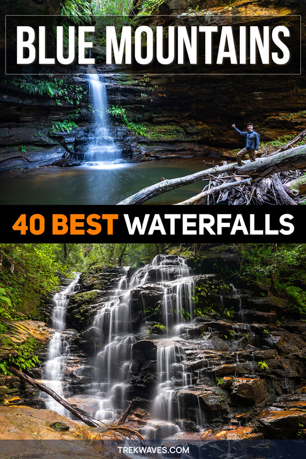
The Blue Mountains is one of the best regions in Australia for chasing waterfalls — and after several years of hiking, exploring hidden trails, and discovering secret pools, I’ve finally put together what I believe is the most comprehensive guide to waterfalls in the Blue Mountains you’ll find online.
There are 40 waterfalls here, and to be honest, I could easily add more. This region is overflowing with natural beauty.
Instead of ranking from top to bottom, this guide is laid out by region, making it easier to plan your own Blue Mountains waterfall adventure.
I’ve broken the list down by region — Central, Upper, and Lower Blue Mountains — to help you plan based on where you’ll be. This is especially useful if you’re a photographer or visiting with limited time, and want to make the most of your trip.
Each area offers its own unique charms and surprises — as you read on, you’ll see why some regions hold a special place for waterfall lovers.
Let’s dive in!
Table of Contents Show
What to Expect in This Guide
In this guide, you’ll find 40 of the best waterfalls in the Blue Mountains, grouped into 3 general regions to help you plan your adventure more efficiently — especially if you’re short on time or focusing your visit around a specific area.
Here’s a quick overview of the regions:
- Lower Blue Mountains – often overlooked, this region hides a number of lush, less-trafficked waterfalls around Lawson, Hazelbrook, Springwood, and Glenbrook — ideal for those seeking peaceful walks and off-the-beaten-path discoveries.
- Upper Blue Mountains – a quieter area stretching around Blackheath and Mount Victoria, home to dramatic single-drop falls and secluded forested cascades, such as Beauchamp Falls and Victoria Falls.
- Central Blue Mountains – this is where you’ll find the most iconic and photogenic waterfalls, including Wentworth Falls, Bridal Veil Falls, Katoomba Falls, and several hidden gems in Leura.
Each entry will include the name of the waterfall (or group of falls), the general location, and useful notes based on personal visits — so you can decide which ones are worth adding to your own Blue Mountains itinerary.
Best Waterfalls in Lower Blue Mountains
If you’re keen to visit multiple waterfalls in one go, the Lower Blue Mountains area is a perfect choice. This region is packed with clustered waterfall trails, particularly in Lawson and Hazelbrook, where you can easily tick off three to five waterfalls on a single short circuit.
These trails tend to be shorter and quieter, making them ideal for peaceful day walks or family-friendly adventures.
Whether you’re after a quick escape from Sydney or just prefer serene rainforest settings over big tourist crowds, the Lower Mountains are well worth exploring.
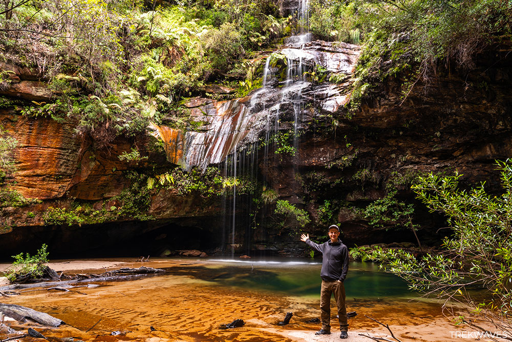
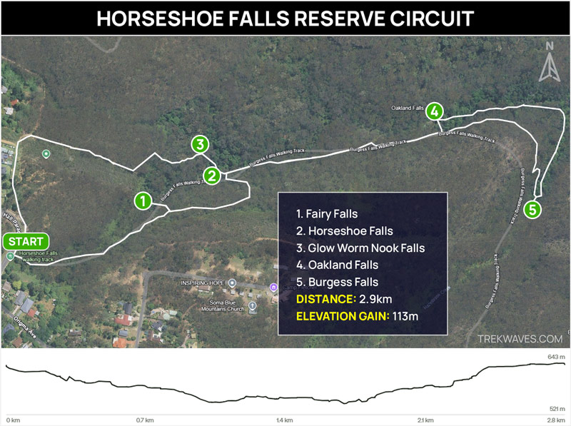
#40 Horseshoe Falls
- Region: Lower Blue Mountains
- Closest Town: Hazelbrook
- Trail distance: 2.9km return (including nearby waterfalls)
- Start & Finish: Oaklands Rd near Horseshoe Falls Reserve
- Difficulty: Easy
- Nearby falls: Oaklands Falls, Burgess Falls, Fairy Falls
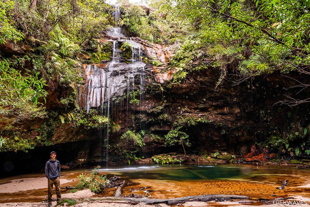
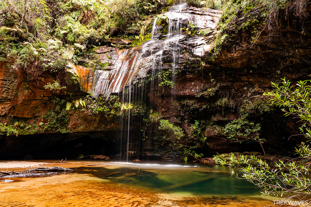
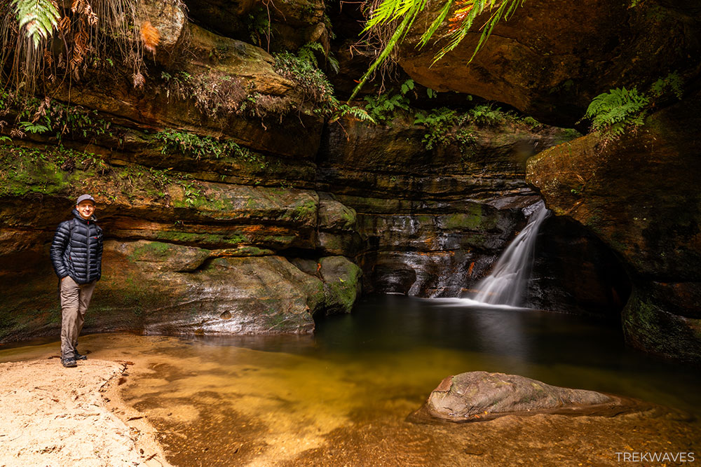
Horseshoe Falls is one of the most unique waterfalls in the Lower Blue Mountains — not because of its height or volume, but because you can actually walk behind it.
Located in the quiet bushland of Hazelbrook, this small but striking waterfall flows over a curved sandstone overhang, creating a natural rock alcove where you can stand behind the gently falling water
The trail to the waterfall is short and easy, with a mix of forested paths, stone steps, and mild rock scrambling — suitable for most fitness levels.
If you don’t mind staying out after dark, bring a headlamp and hang around — the damp rock walls behind the waterfall are home to a small glow worm colony.
You can extend your walk to include nearby Oakland Falls and Burgess Falls, all accessible via the same circuit. It’s a short loop, but packed with charm — perfect if you’re chasing quiet, lesser-known waterfalls away from the crowds.
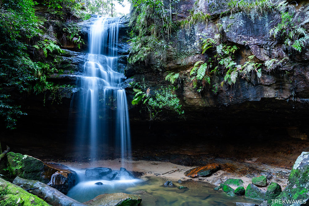
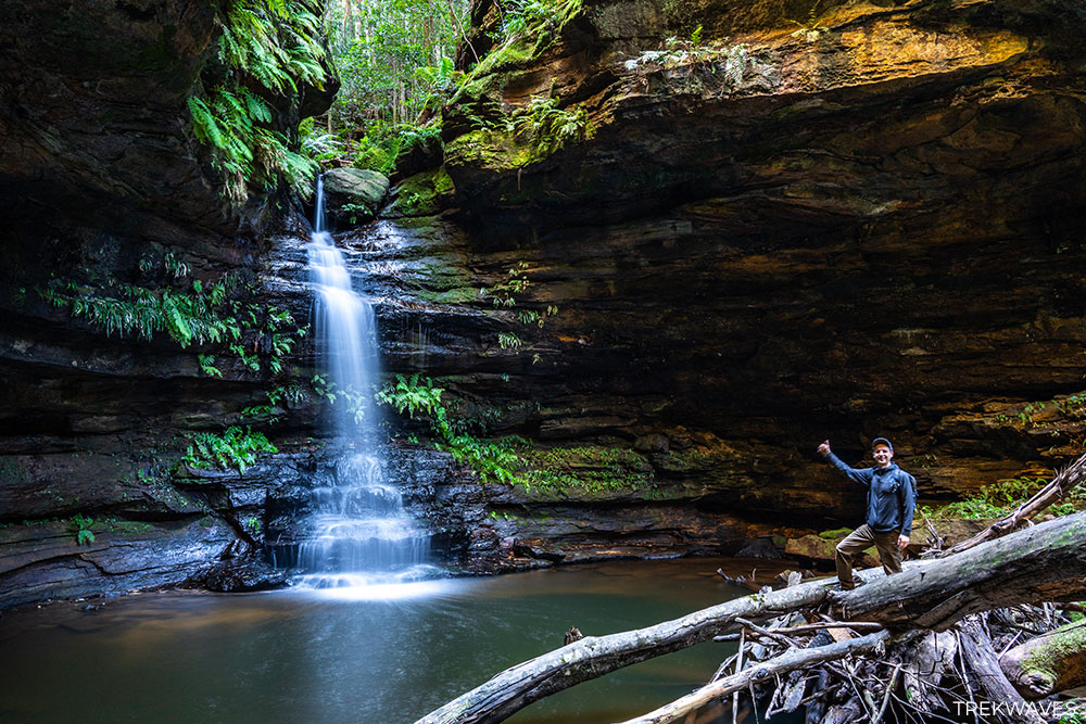
#39 Oakland Falls
- Region: Lower Blue Mountains
- Closest Town: Hazelbrook
- Trail distance: 2.9km return (including nearby waterfalls)
- Start & Finish: Oaklands Rd near Horseshoe Falls Reserve
- Difficulty: Easy / Moderate
- Nearby falls: Horseshoe Falls, Burgess Falls, Fairy Falls
If you’re doing the Hazelbrook Waterfall Circuit, Oaklands Falls is the next stop — located 10-15 minutes past Horseshoe Falls.
It’s a smaller waterfall, but still a really rewarding one — especially because, like Horseshoe Falls, you can step behind the curtain of water.
The cascade drops gently over a sandstone ledge into a small pool surrounded by trees, ferns and moss-covered boulders.
It’s a charming spot where you can pause and take in the sound of the falls before continuing along the trail.
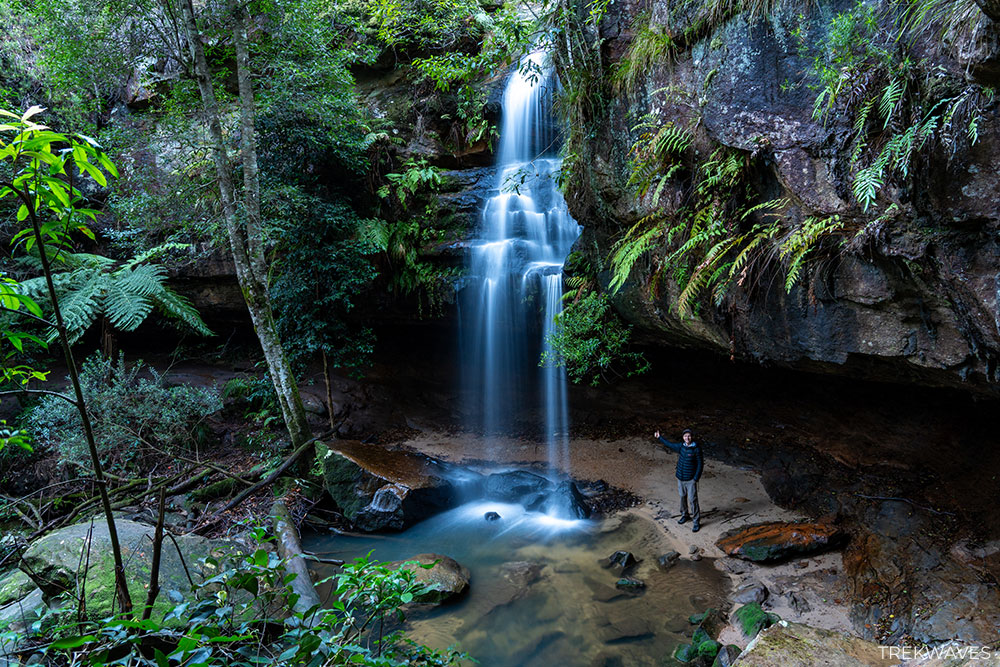
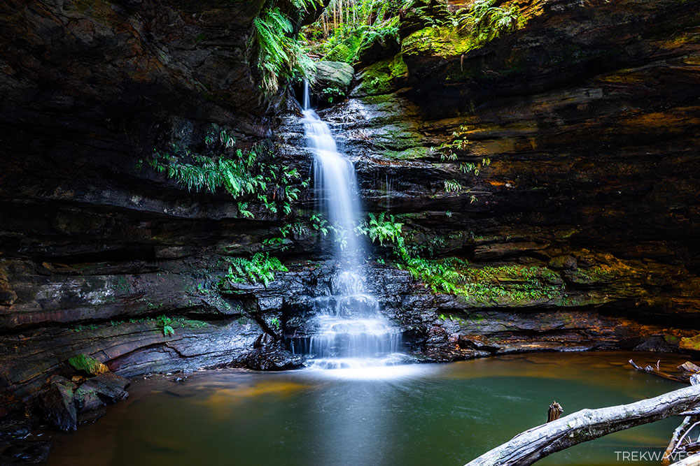
#38 Burgess Falls
- Region: Lower Blue Mountains
- Closest Town: Hazelbrook
- Trail distance: 2.9km return (including nearby waterfalls)
- Start & Finish: Oaklands Rd near Horseshoe Falls Reserve
- Difficulty: Easy / Moderate
- Nearby falls: Horseshoe Falls, Oakland Falls, Fairy Falls
Burgess Falls is the final and most secluded waterfall on the Horseshoe Falls Reserve Circuit. Although it’s smaller than Horseshoe or Oaklands Falls, its peaceful setting and mossy, fern-lined surroundings make it a rewarding destination.
The waterfall gently cascades into a shaded grotto, offering a tranquil spot to rest before heading back.
Reaching Burgess Falls involves a longer walk, with some uneven and potentially muddy sections, especially after rain. However, the effort is worthwhile for those seeking a quiet, off-the-beaten-path experience.
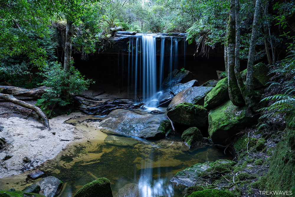
#37 Edith Falls
- Region: Lower Blue Mountains
- Closest Town: Woodford
- Trail distance: 3.5km loop (including nearby waterfalls)
- Start & Finish: End of Woodbury Street
- Difficulty: Easy
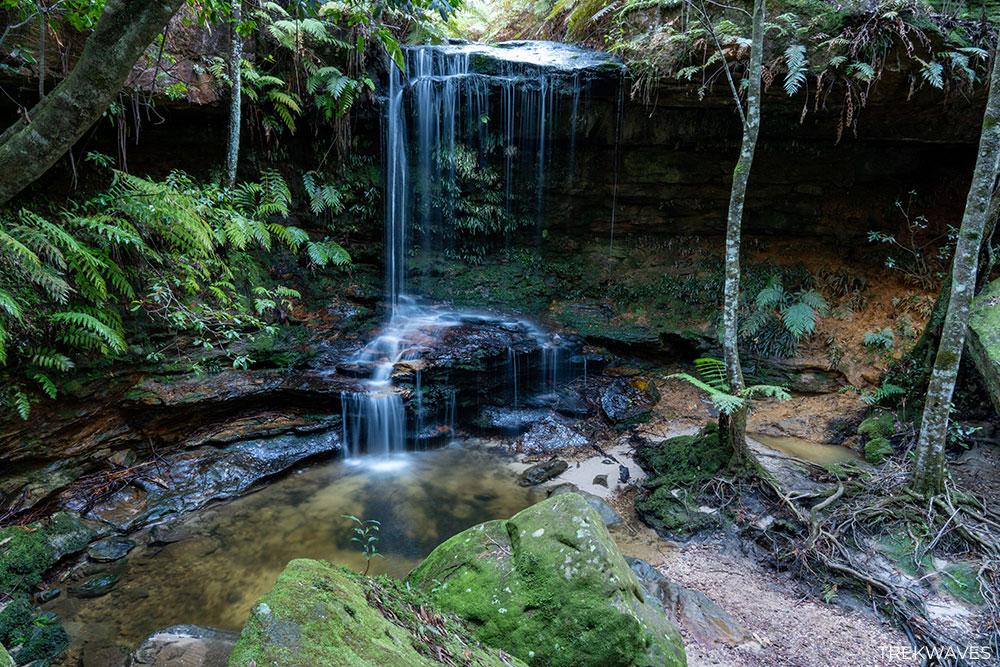
- Nearby falls: Mabel Falls, Hazel Falls
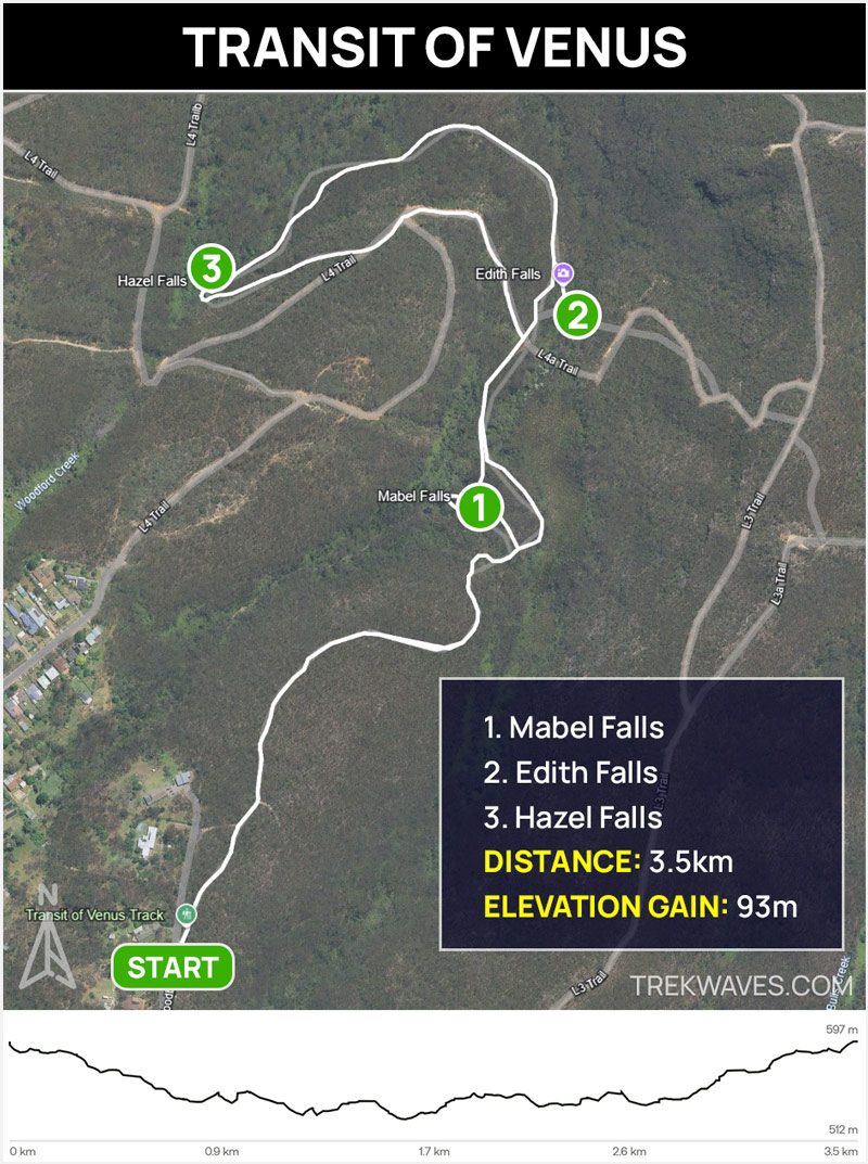
Located along the scenic Transit of Venus walking track in Woodford, Edith Falls may not be tall or powerful, but the setting is full of charm.
The falls tumble into a small clearing with a sandy patch at the base, surrounded by lush green ferns that give the spot a peaceful, enclosed feel.
It’s a great place to pause and soak in the quiet atmosphere before continuing on the 3.5 km loop. The track is easy and family-friendly, and also passes Mabel Falls and Hazel Falls, making this a rewarding short walk packed with variety.
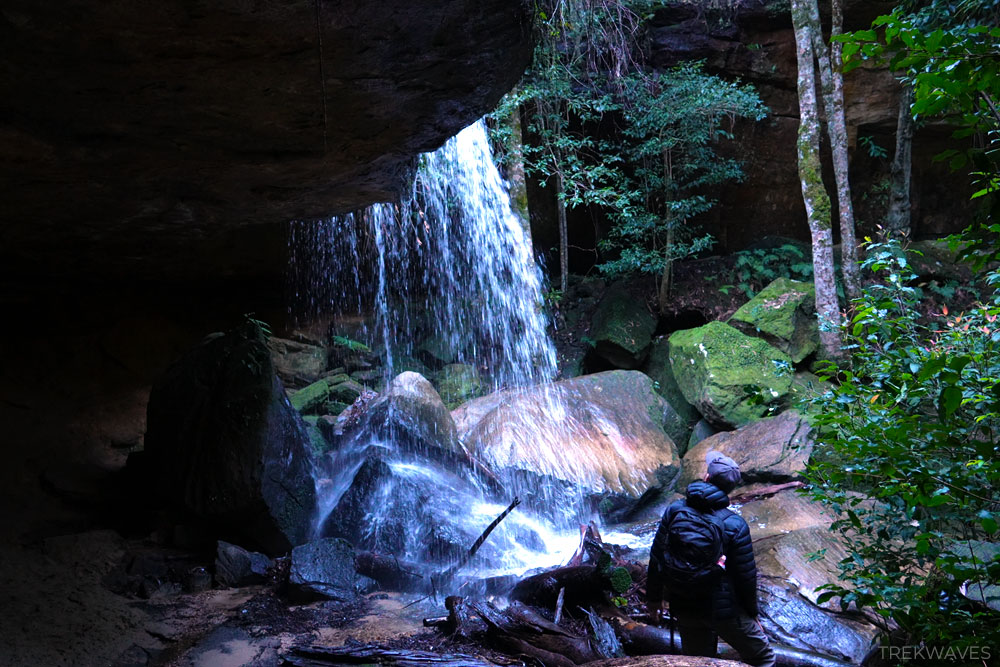
#36 Hazel Falls
- Region: Lower Blue Mountains
- Closest Town: Woodford
- Trail distance: 3.5km loop (including nearby waterfalls)
- Start & Finish: End of Woodbury Street
- Difficulty: Easy
- Nearby falls: Edith Falls, Mabel Falls
Hazel Falls is the last waterfall on the Transit of Venus loop in Woodford, and while it’s not huge, it has a lot of charm.
The fall is slightly taller than Edith Falls and plunges behind a sandstone overhang into a quiet pool, giving you the unique chance to walk right behind the water curtain.
When I was there, the water flow was modest, but the rain-soaked cliffs and dripping foliage created a lush, almost cinematic atmosphere.
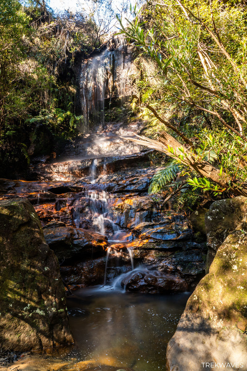
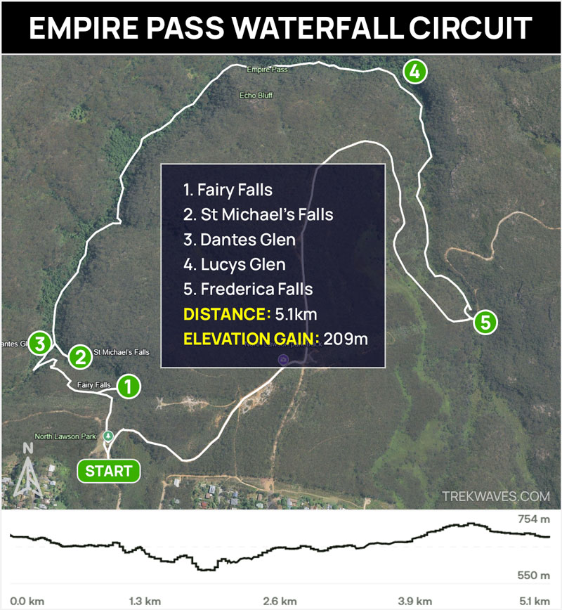
#35 Fairy Falls
- Region: Lower Blue Mountains
- Closest Town: Lawson
- Trail distance: 5.1km loop (including nearby waterfalls)
- Start & Finish: North Lawson Park
- Difficulty: Easy
- Nearby falls: Dantes Glen, St Michaels Falls, Lucys Glen, Frederica Falls
- Full Trail Guide: Empire Pass Walking Track: North Lawson
- Trail Video: Click here to watch on YouTube
Fairy Falls is the first waterfall you’ll reach on the North Lawson Waterfall Circuit. It’s just a few minutes from the car park at the end of St Bernards Drive, and the track is easy to follow.
Fairy Falls isn’t the tallest waterfall on the circuit, but it stands out thanks to its striking backdrop. Water flows gently over wide orange sandstone ledges, with vivid tones of red, orange, and yellow that contrast beautifully with the surrounding green ferns.

The track is easy-going, though it can be a little slippery after rain. It’s a good warm-up before heading on to Dantes Glen and the rest of the trail.
#34 Dantes Glen
- Region: Lower Blue Mountains
- Closest Town: Lawson
- Trail distance: 5.1km loop (including nearby waterfalls)
- Start & Finish: North Lawson Park
- Difficulty: Easy / Moderate (steep descent)
- Nearby falls: Fairy Falls, St Michaels Falls, Lucys Glen, Frederica Falls
- Full Trail Guide: Empire Pass Walking Track: North Lawson
- Trail Video: Click here to watch on YouTube
Dantes Glen is the next waterfall you’ll reach after Fairy Falls on the North Lawson Waterfall Circuit, and it’s one of the most peaceful spots along the track.
The trail heads downhill through fern-filled rainforest, with several stone steps and handrails to help you navigate the steeper parts.
This one’s my personal favourite along the North Lawson Waterfall Circuit. The surrounding forest and natural amphitheatre give it a very calming feel.
The falls flow gently over a narrow ledge into a shallow pool, surrounded by mossy boulders, ferns, and overhanging rock walls.
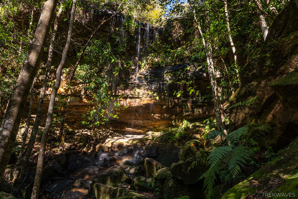
#33 St Michaels Falls
- Region: Lower Blue Mountains
- Closest Town: Lawson
- Trail distance: 5.1km loop (including nearby waterfalls)
- Start & Finish: North Lawson Park
- Difficulty: Easy / Moderate (steep descent)
- Nearby falls: Fairy Falls, Dantes Glen, Lucys Glen, Frederica Falls
- Full Trail Guide: Empire Pass Walking Track: North Lawson
- Trail Video: Click here to watch on YouTube
St Michaels Falls is a third waterfall along the North Lawson Empire Pass circuit. It’s set in a shaded gully surrounded by tree ferns and sandstone, where the water flows gently over a rock ledge into a shallow pool.

When I visited, the flow was fairly light, and the water levels were low — but I’ve seen photos of this spot after heavy rain, and it transforms completely.
A wide, deep pool forms at the base, and the falls become much more dramatic. If you can, time your walk after recent rainfall — my photos definitely don’t do this place justice.
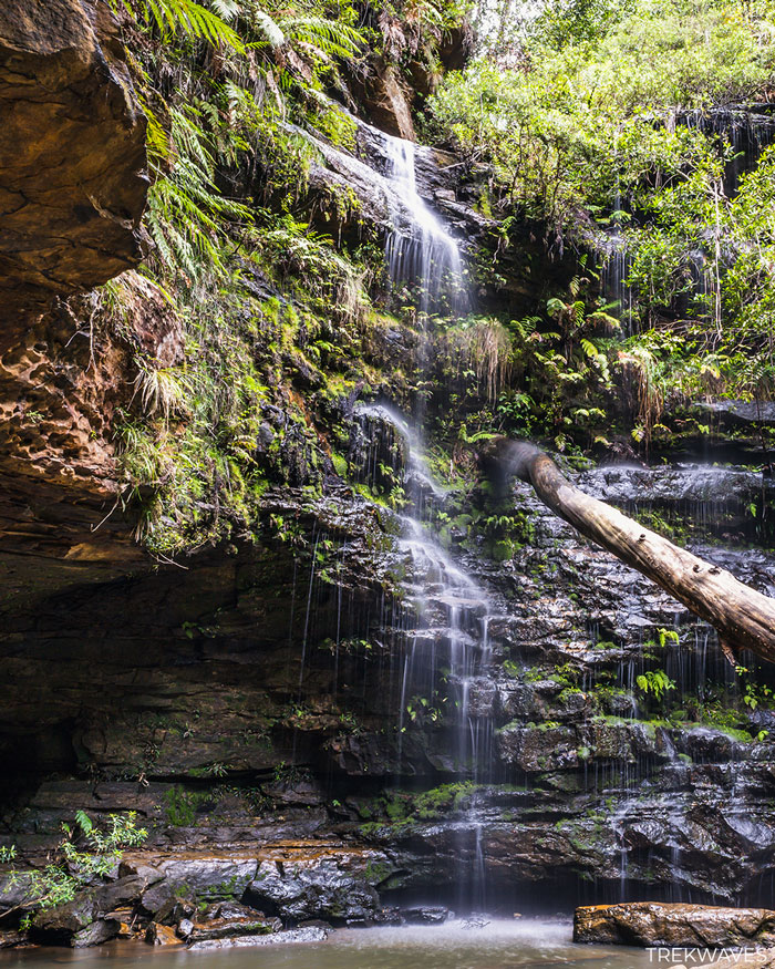
#32 Adelina Falls
- Region: Lower Blue Mountains
- Closest Town: Lawson
- Trail distance: 3.1km loop (including nearby waterfalls)
- Start & Finish: Honour Ave
- Difficulty: Easy
- Nearby falls: Junction Falls, Federal Falls, Cataract Falls
- Full Trail Guide: South Lawson 5 Waterfall Circuit
- Trail Video: Click here to watch on YouTube
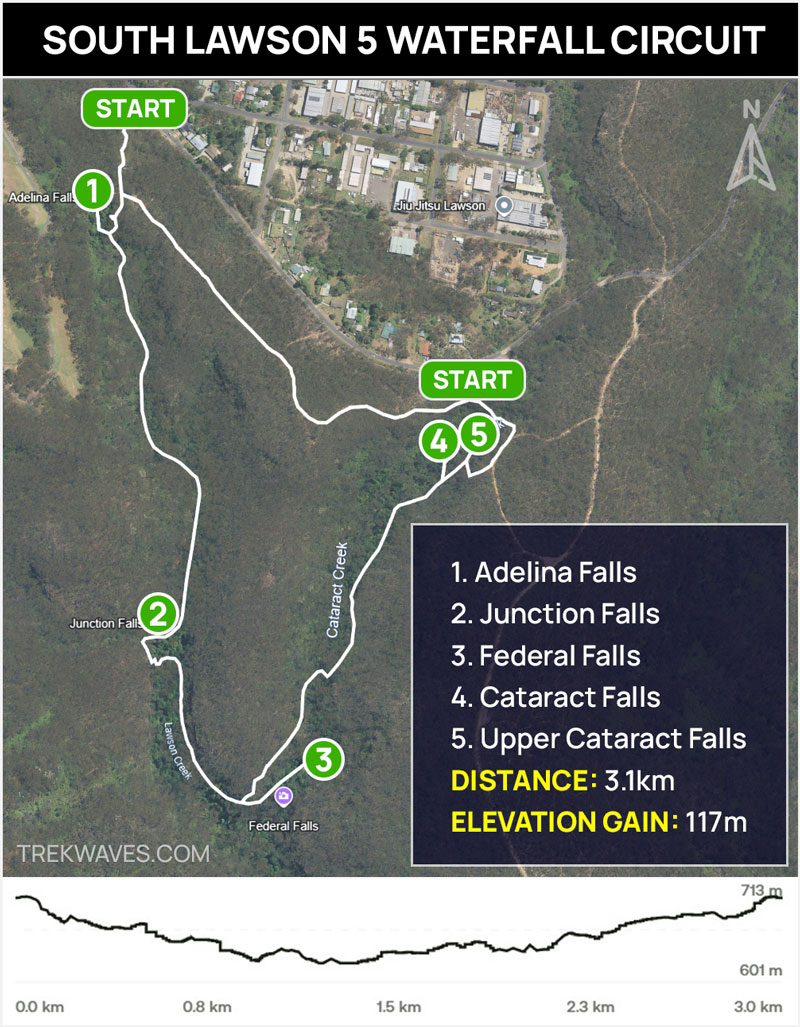
Adelina Falls is the first waterfall you’ll reach on the South Lawson Waterfall Circuit, and it sets the tone beautifully for what’s ahead.
It’s a two-tiered cascade that drops around 10–15 metres into a shallow pool, framed by mossy rocks, ferns, and tall bushland.
Adelina Falls was formerly known as Livingstone Falls but was renamed in honuor of Adelaide Mary Wilson, affectionately called Adelina, the daughter of the owners of the original Blue Mountain Inn in Lawson.
It’s only a short walk from the Honour Avenue entrance, and easy to reach even if you’re not doing the full loop.
When I visited, the flow was fairly light — but after solid rainfall, the scene transforms with a stronger cascade and fuller pool.
#31 Junction Falls
- Region: Lower Blue Mountains
- Closest Town: Lawson
- Trail distance: 3.1km loop (including nearby waterfalls)
- Start & Finish: Honour Ave
- Difficulty: Easy / Moderate
- Nearby falls: Adelina Falls, Federal Falls, Cataract Falls
- Full Trail Guide: South Lawson 5 Waterfall Circuit
- Trail Video: Click here to watch on YouTube
Junction Falls is around the midpoint of the South Lawson circuit, and it’s one of the more impressive waterfalls on the track.
Located approximately 0.9 km from the northern trailhead, the falls are formed by the merging of Ridge Creek and Lawson Creek.
It’s around the halfway mark of the loop and one of the larger falls on the track. The flow is usually steady, but it looks best after recent rain when the water spreads wider across the rocks.
Right next to Junction Falls, you’ll find a smaller, unnamed waterfall that’s surprisingly scenic and worth a quick stop before heading toward Federal Falls.
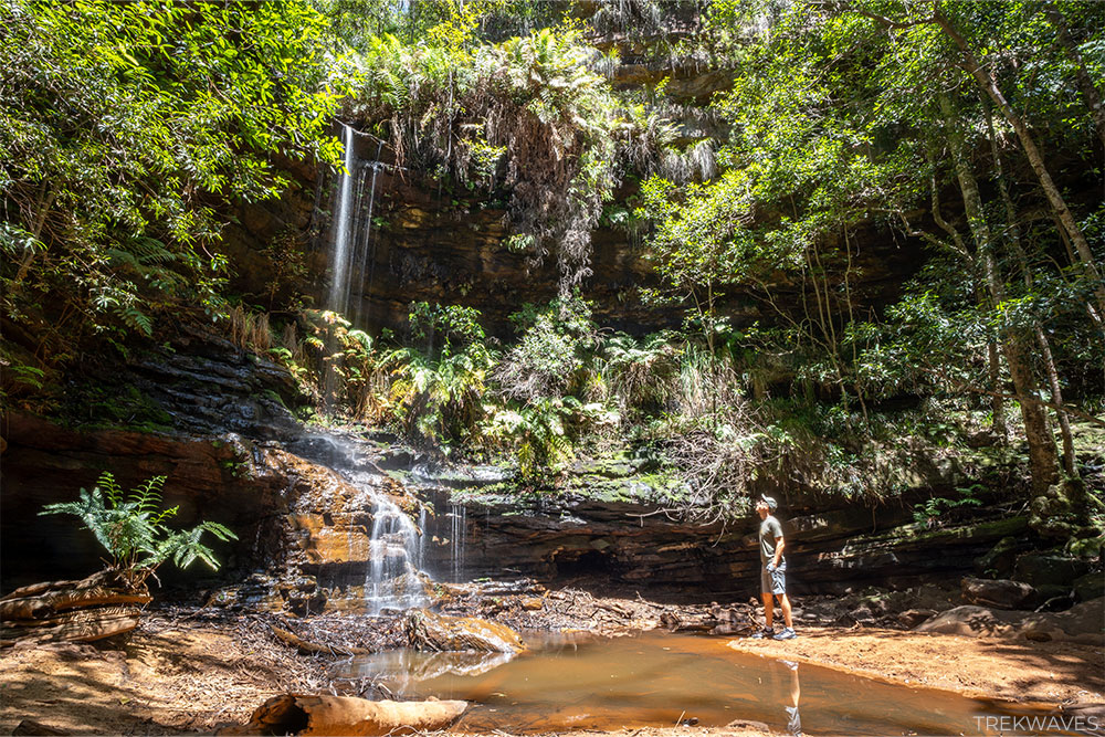
#30 Federal Falls
- Region: Lower Blue Mountains
- Closest Town: Lawson
- Trail distance: 3.1km loop (including nearby waterfalls)
- Start & Finish: Honour Ave
- Difficulty: Easy / Moderate
- Nearby falls: Adelina Falls, Junction Falls, Cataract Falls
- Full Trail Guide: South Lawson 5 Waterfall Circuit
- Trail Video: Click here to watch on YouTube
Federal Falls stands out as my personal favourite among the waterfalls on the South Lawson Waterfall Circuit.
This gentle cascade spills into a wide, sandy pool, creating a calm and scenic spot in the heart of the bush.
The sandy base adds a unique touch, making it a pleasant place to sit and enjoy the surroundings.
The track to Federal Falls is well-marked and easy to follow, but since it branches off the main trail, it’s easy to miss if you’re not paying attention — keep an eye out for the sign.
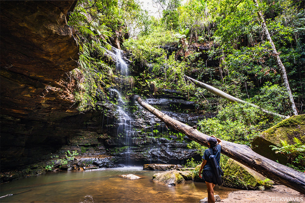
#29 Cataract Falls (Upper & Lower)
- Region: Lower Blue Mountains
- Closest Town: Lawson
- Trail distance: 3.1km loop (including nearby waterfalls)
- Start & Finish: Honour Ave
- Difficulty: Easy / Moderate
- Nearby falls: Adelina Falls, Junction Falls, Federal Falls
- Full Trail Guide: South Lawson 5 Waterfall Circuit
- Trail Video: Click here to watch on YouTube
Lower Cataract Falls is the final waterfall on the South Lawson Waterfall Circuit if you’re walking in a counter-clockwise direction.
This multi-tiered cascade flows over smooth rock ledges into a clear, shallow pool, framed by vibrant greenery on all sides.
Before wrapping up the circuit, consider a brief stop at the Upper Cataract Falls. Situated just upstream, this smaller waterfall offers a unique vantage point and complements the experience of the lower falls.
If you’re walking this track around dusk or at night, keep an eye out for glow worms around the sandstone overhangs near Cataract Falls.
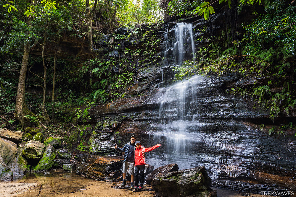
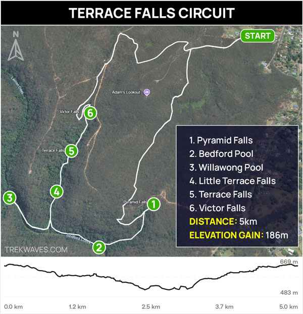
#28 Pyramid Falls
- Region: Lower Blue Mountains
- Closest Town: Hazelbrook
- Trail distance: 5km loop (including nearby waterfalls)
- Start & Finish: The end of Lake Road
- Difficulty: Moderate
- Nearby falls: Little Terrace Falls, Terrace Falls, Victor Falls
- Trail Video: Click here to watch on YouTube
Pyramid Falls is one of the quieter stops along the Terrace Falls Reserve Circuit in Hazelbrook. It’s a small, stepped waterfall that flows over a series of rock shelves into a shallow pool, surrounded by ferns and large boulders.
Accessing Pyramid Falls involves a short detour from the main trail. It’s easy to miss, so keep an eye out for the short side track, which will guide you to the falls.
While not as tall or dramatic as some others in the area, it has a peaceful feel and is well worth the visit.
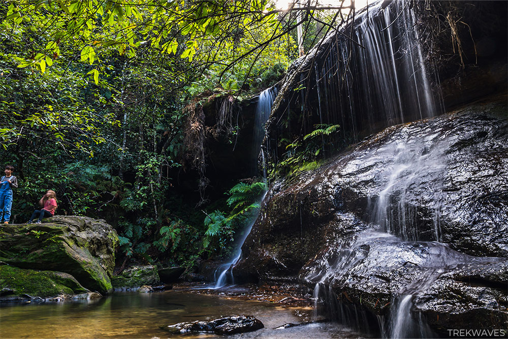
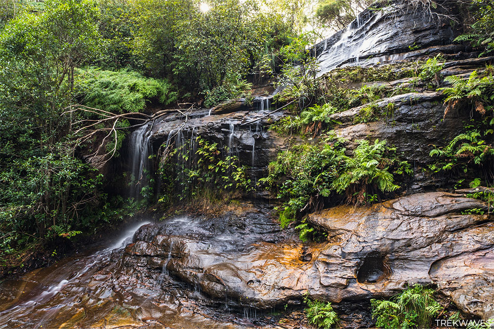
#27 Terrace Falls & Little Terrace Falls
- Region: Lower Blue Mountains
- Closest Town: Hazelbrook
- Trail distance: 5km loop (including nearby waterfalls)
- Start & Finish: The end of Lake Road
- Difficulty: Moderate
- Nearby falls: Pyramid Falls, Victor Falls
- Trail Video: Click here to watch on YouTube
Terrace Falls is the most impressive waterfall on the Terrace Falls Reserve Circuit — and easily my personal favourite.
It’s a long, multi-tiered cascade that flows down a beautifully layered rock face into a shaded gully surrounded by tall trees and ferns.
The trail down can be a bit rough in sections, but it’s not overly difficult and definitely worth the effort. You’ll likely have it all to yourself, too — this spot doesn’t get many crowds, which adds to its charm.
Before you reach Terrace Falls, you’ll pass Little Terrace Falls — a lovely smaller cascade that spills into a crystal-clear pool.
It’s a great place to pause, dip your feet, or take a few quiet moments before continuing on.
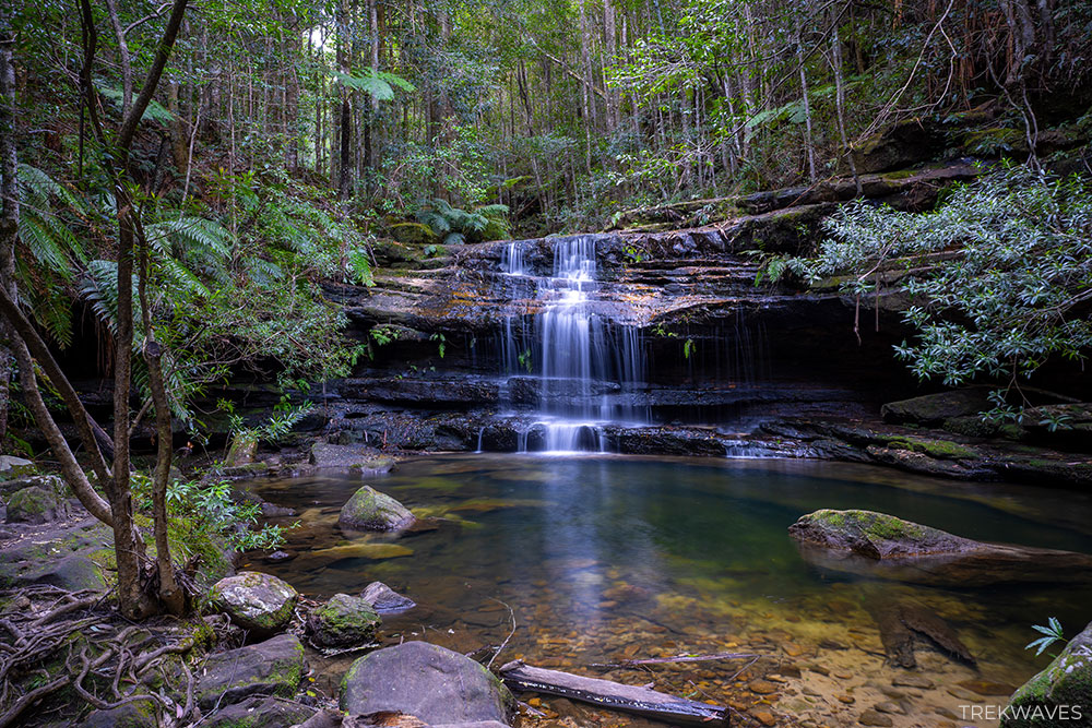
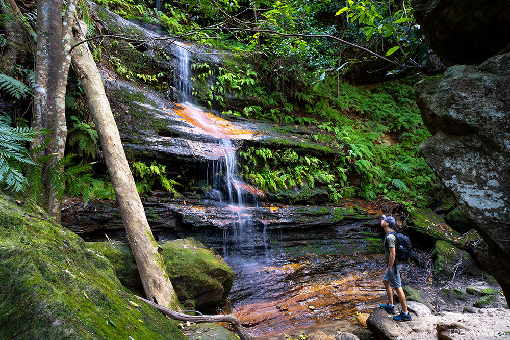
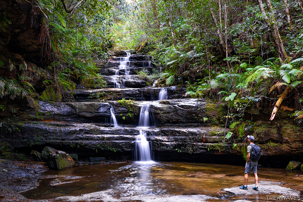
#26 Grey Hat Falls
- Region: Lower Blue Mountains
- Closest Town: Glenbrook
- Trail distance: 1.9km return
- Start & Finish: Red Hands Fire Trail
- Difficulty: Medium / Hard
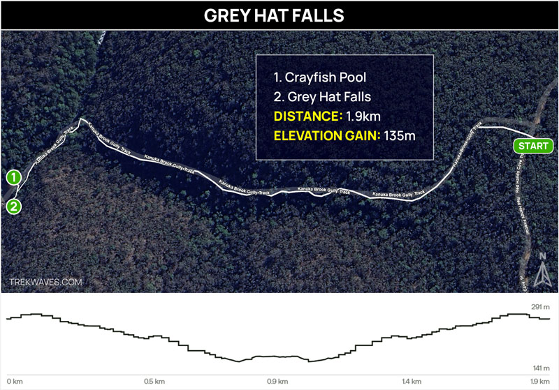
Grey Hat Falls and Crayfish Pool are among the most stunning spots I’ve explored in the Lower Blue Mountains.
The trail to reach them is short but steep, with some rock scrambling involved, making the journey feel like a true adventure.
The falls flow into a stunning emerald-green pool surrounded by vibrant sandstone walls and lush bushland.
Crayfish Pool, fed by the pristine Kanuka Brook, is deep, clear, and easily one of the best swimming spots in the Lower Blue Mountains.
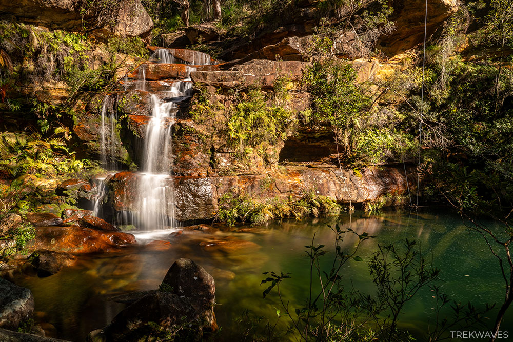
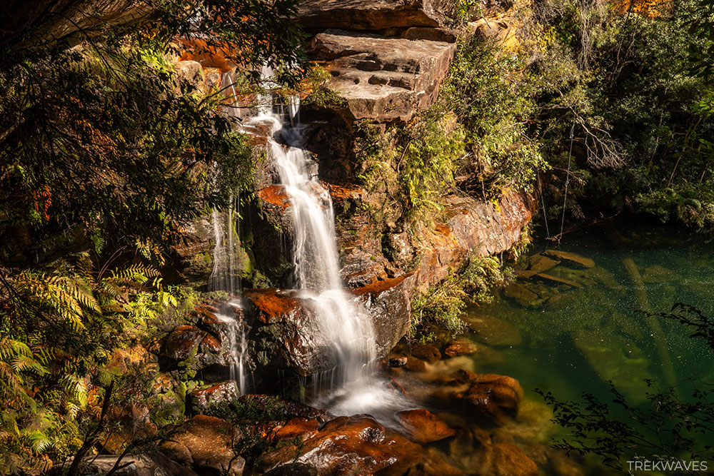
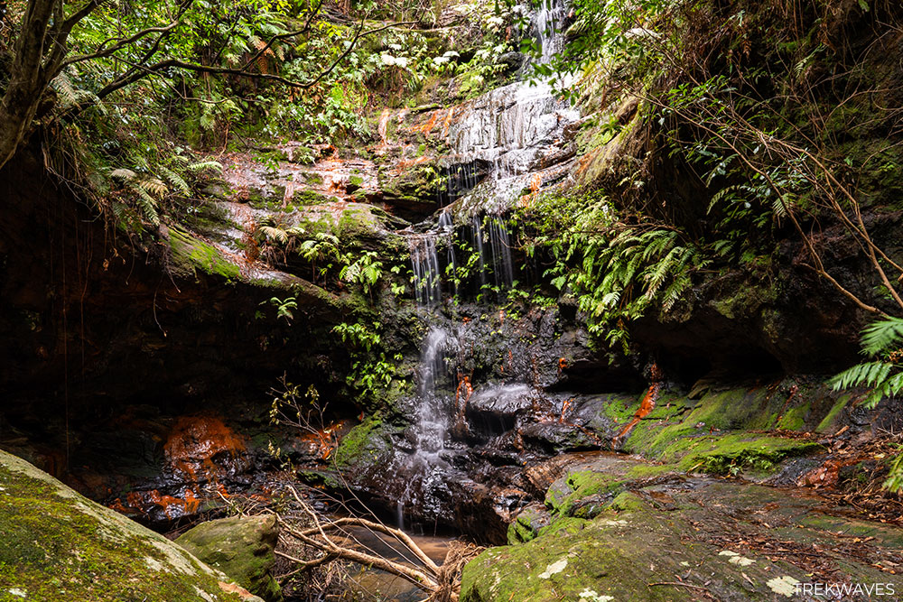
#25 Numantia Falls
- Region: Lower Blue Mountains
- Closest Town: Faulconbridge
- Trail distance: 5.3km return
- Start & Finish: Sir Henrys Parade
- Difficulty: Hard (unmarked, overgrown trail)
- Nearest falls: Clarinda Falls
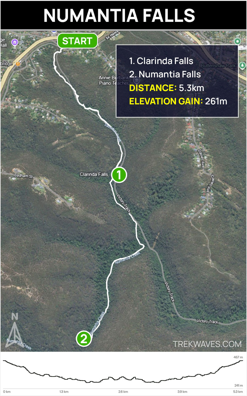
Starting from Faulconbridge, the trail to Numantia Falls takes you along the Victory Track through a stunning, fern-filled rainforest.
The first stop, Clarinda Falls, is a lovely cascade in a peaceful setting — a great spot to pause before tackling the harder part of the trail.
At the junction where Numantia Creek meets Sassafras Creek, the track becomes unmarked and significantly more challenging.
During my hike, I encountered numerous obstacles, including many fallen trees and slippery sections, making the journey physically demanding.
It required a fair bit of climbing and maneuvering, making it unsuitable for those new to bushwalking or those looking for an easy walk.
The effort pays off at Numantia Falls, where a beautiful waterfall drops into a clear, emerald pool surrounded by towering cliffs and dense vegetation.
It’s a secluded and picturesque spot, perfect for those seeking a more adventurous hike.
#24 Lawson Cave Falls
- Region: Lower Blue Mountains
- Closest Town: Bullaburra
- Trail distance: 2.5km return
- Start & Finish: 101 Kent Street (there is currently no access from Booth Rd)
- Difficulty: Hard (unmarked, overgrown trail)
Lawson Cave Falls is one of the secret waterfalls on Bruce’s Walk—north of Bullaburra, heading west along the old Skarratts Track.
The route isn’t your average bush stroll. It’s steep, unmarked, and littered with fallen trees and debris—especially after rain when everything’s mucked in mud.
Expect to spend most of the hike climbing over fallen trees, squeezing under overgrowth and walking on slippery rocks — especially if you head out after wet weather.
It’s a serious challenge, not to be tackled by beginners, but reaching the amphitheatre where the waterfall drops into a dark cave is absolutely worth it.
This hidden cave waterfall was included in the early days of Bruce’s Walk, though it slipped off most maps until bushwalkers brought it back into the spotlight in recent years.
If you’re willing to put in the effort and time it right (pick a dry day), this could be one of the most beautiful falls you’ll see in the Lower Blue Mountains.
Upper Blue Mountains
The Upper Blue Mountains is home to some of the most scenic and dramatic waterfalls in the entire region. This area features the tallest single-drop waterfalls in the Blue Mountains, surrounded by towering cliffs and deep valleys.
Waterfall walks here are usually longer and steeper, but they also tend to be quieter and more rewarding. If you’re looking for big views and a more adventurous experience, the Upper Blue Mountains delivers some of the best waterfall hikes in New South Wales.
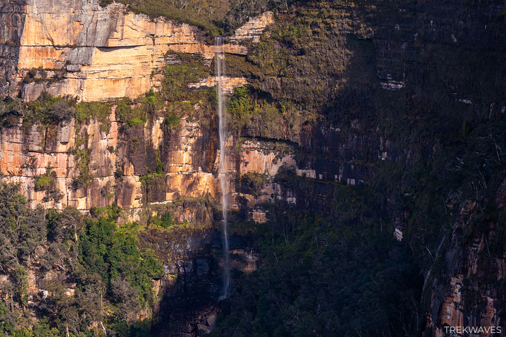
#23 Fortress Falls
- Region: Upper Blue Mountains
- Closest Town: Leura and Wentworth Falls
- Trail distance: 7.1km return
- Start & Finish: Fortress Ridge Carpark (Mt Hay Road)
- Difficulty: Medium
- Trail Video: Click here to watch on YouTube
Fortress Falls is best enjoyed from the lookout just past the Lockley Pylon summit. From here, you get a stunning view of the waterfall cascading down the cliffs into the valley below — definitely one of the most impressive sights in the Upper Blue Mountains.
While it’s possible to reach the base of Fortress Falls, the trail is extremely difficult, unmarked, and involves serious scrambling. I wouldn’t recommend this for anyone without plenty of experience and fitness.
Another way to get closer to the falls is by taking the Fortress Ridge Trail. This challenging route leads you to the top of the falls, where you’ll find some incredible views looking back toward Lockleys Pylon.
There are also a few natural rock pools at the top that are perfect for a refreshing dip on a hot day. Just keep in mind this trail is tough, with steep sections and rock scrambling — definitely not for beginners.

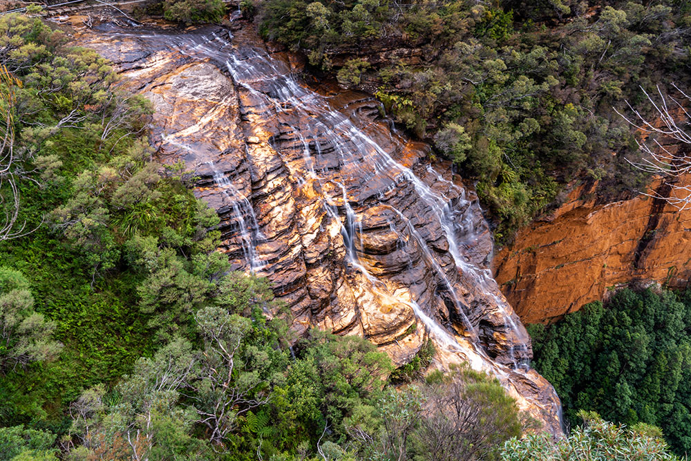
#22 Horseshoe Falls (Grose Valley)
- Region: Upper Blue Mountains
- Closest Town: Blackheath
- Trail distance: 2km return (Govetts Leap Lookout to Cripps Loookout)
- Start & Finish: Govetts Leap Lookout
- Difficulty: Easy / Medium
- Trail Video: Click here to watch on YouTube
The best way to experience Horseshoe Falls is by hiking the Pulpit Rock Track, which starts from Govetts Leap Lookout in Blackheath.
This well-marked trail first leads to Horseshoe Falls Lookout, offering a great top-down view of the waterfall as it flows into the Grose Valley.
If you want the full panoramic view of Horseshoe Falls, keep following the track to Cripps Lookout.
This lookout is about 2 km return from Govetts Leap and provides sweeping vistas of the falls in all their glory, plus stunning views across the valley.
This hike is moderate in difficulty, with some rocky and uneven parts. The Grose Valley scenery along the way adds to the overall appeal, making this one of the best waterfall walks in the Upper Blue Mountains.
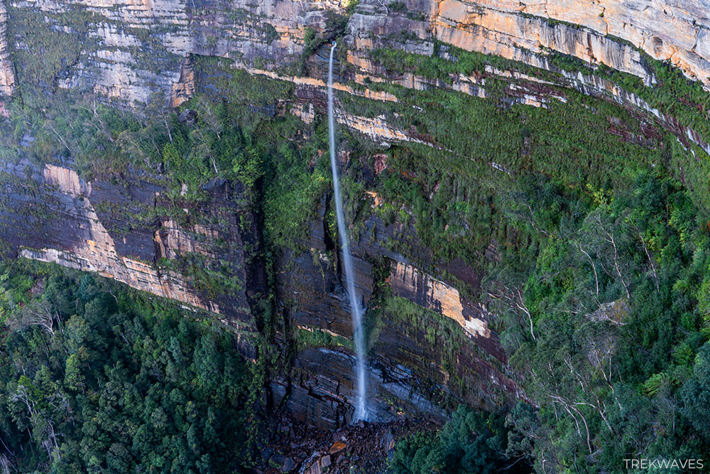
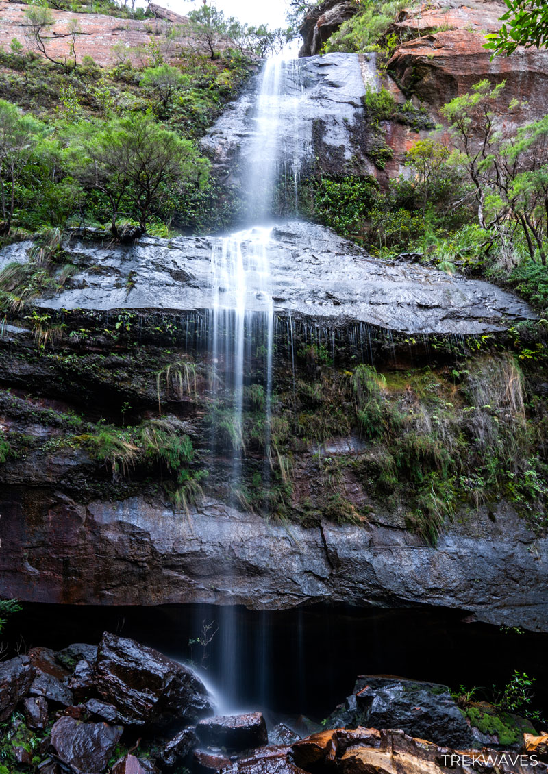
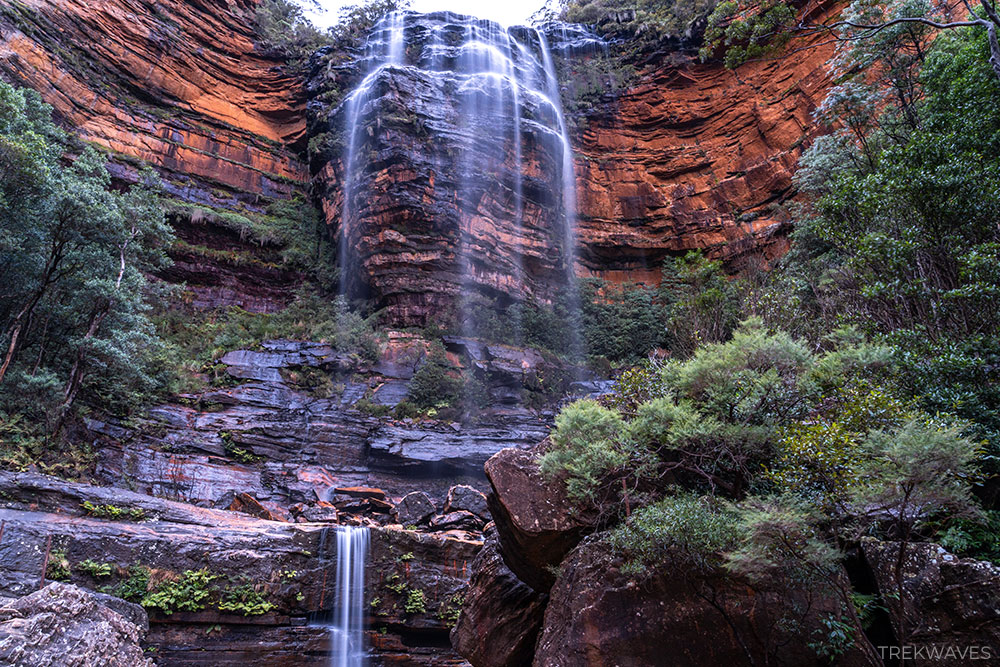
#21 Govetts Leap Falls (or Bridal Veil Falls)
- Region: Upper Blue Mountains
- Closest Town: Blackheath
- Start & Finish: Govetts Leap Lookout
- Difficulty: Easy
- Trail Video: Click here to watch on YouTube
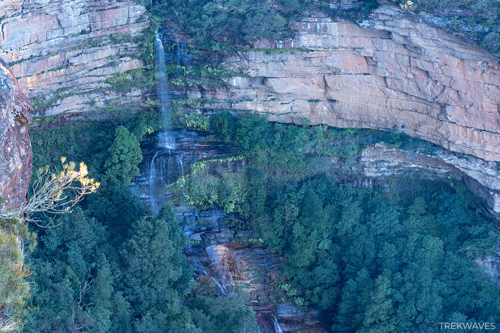
Govetts Leap Falls, also known as Bridal Veil Falls, is the tallest single-drop waterfall in the Blue Mountains, plunging about 180 metres into the Grose Valley.
The easiest and best way to see the falls is by stopping at Govetts Leap Lookout, which offers a spectacular direct view over the valley and waterfall.
If you want to see Govetts Leap Falls from different perspectives, it’s worth taking the Pulpit Rock Track.
This roughly 7 km return walk follows the cliff edges and passes several viewpoints, giving you multiple angles of the falls as well as stunning views across the surrounding valley.
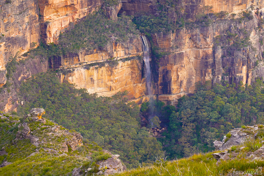
#20 The Grotto in Centennial Glen
- Region: Upper Blue Mountains
- Closest Town: Blackheath
- Trail distance: 4.5km loop (distance of the entire trail)
- Start & Finish: The end of Burton or Bundarra Road
- Difficulty: Moderate / Hard
- Nearby falls: Slippery Dip Falls
- Trail Guide: Porters Pass & Colliers Causeway Circuit
- Trail Video: Click here to watch on YouTube
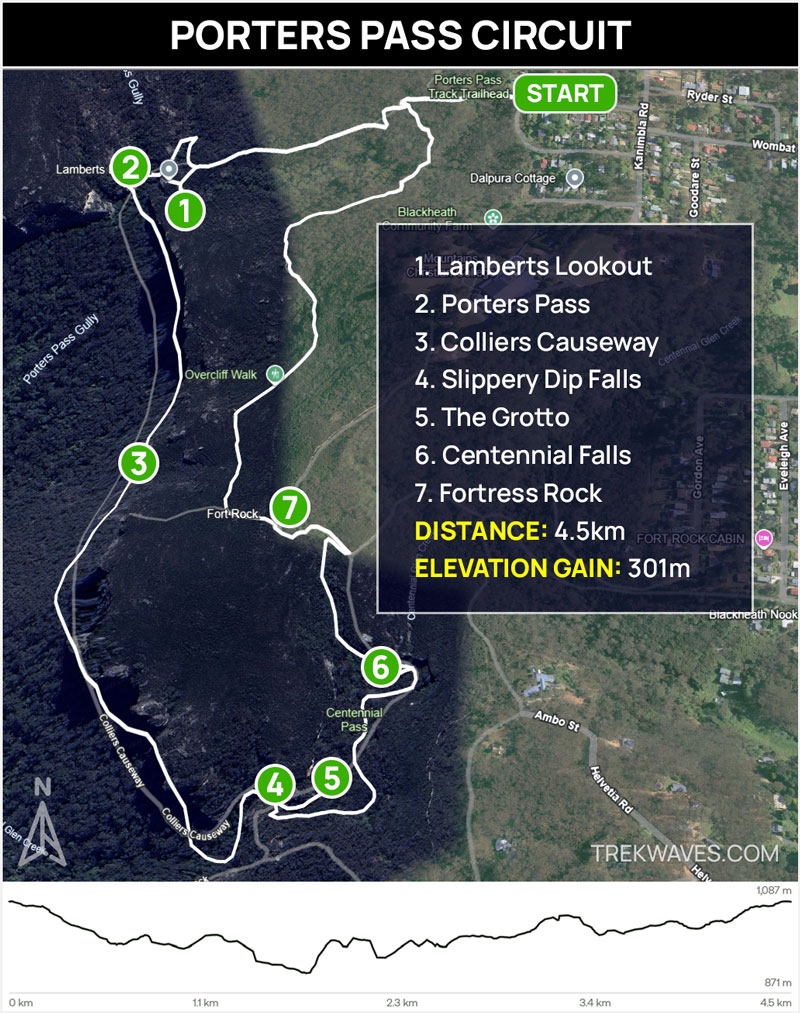
The Grotto Waterfall sits inside a small slot canyon in Centennial Glen, on the Porters Pass Circuit near Blackheath.
After getting through Colliers Causeway and passing Slippery Dip Falls, you’ll reach a signed junction where you need to follow the “Canyon” sign.
The canyon is only about 50 metres from the signpost. To get right up to the waterfall, you can take off your shoes and walk through the middle of the stream, or try your luck scrambling along the narrow ledge on the right side.
It’s one of the most memorable spots on the loop — getting inside the canyon adds an extra sense of adventure and is totally worth the effort.
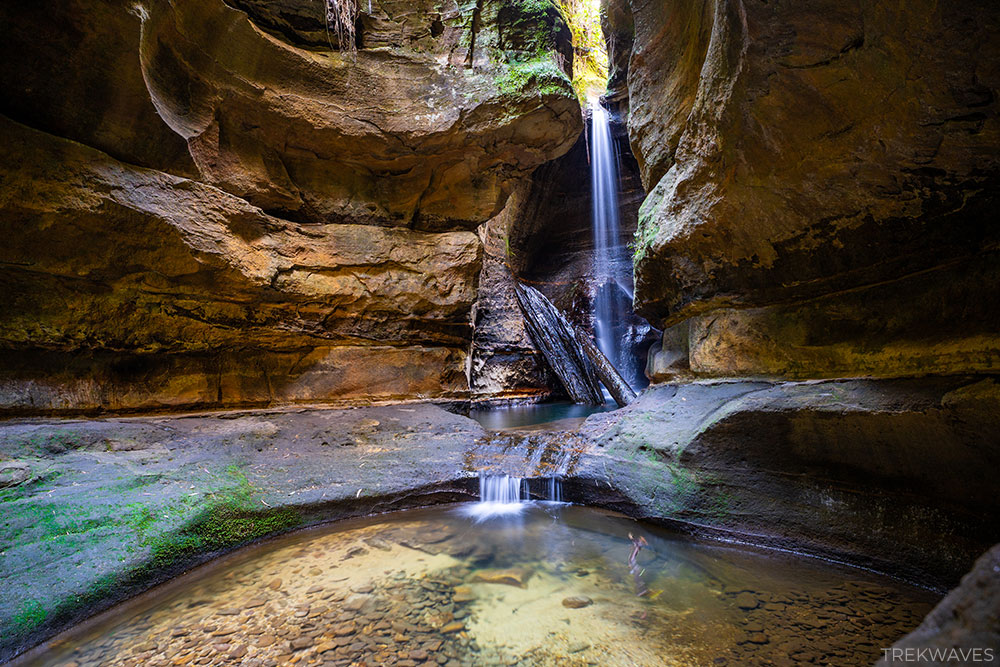
#19 Victoria Falls
- Region: Upper Blue Mountains
- Closest Town: Mt Victoria
- Trail distance: 4.4km return
- Start & Finish: The end of Victoria Falls Road
- Difficulty: Moderate / Hard
- Nearby falls: Victoria Cascades
- Trail Guide: Victoria Falls Walking Track
- Trail Video: Click here to watch on YouTube
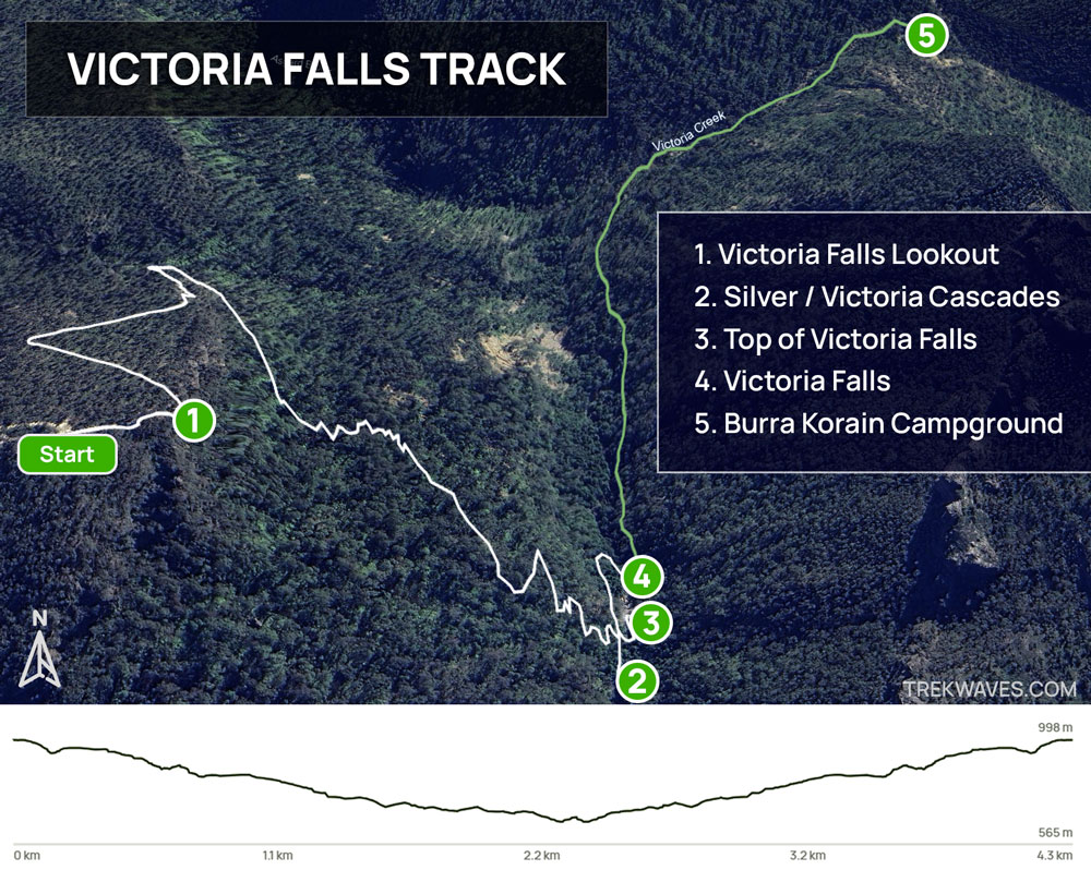
The Victoria Falls walking track near Mount Victoria leads down into the Grose Valley to two stunning waterfalls: Victoria Cascades (also known as Silver Cascades) and Victoria Falls itself.
It’s a 4.4 km return route with a steep descent and climb, offering a rewarding mix of tall cliff views and lush rainforest.
Victoria Cascades is a beautiful, tiered series of cascades that’s perfect for a quick dip, especially on hot days.
But the real highlight is Victoria Falls, a dramatic 20 m drop from a wide sandstone ledge into a clear pool surrounded by rainforest.
There’s even a chance to walk behind the falls or swim in the refreshing plunge pool. Just be prepared—the descent is steep, and the climb back up takes effort, especially on hot days.
#18 Beauchamp Falls
- Region: Upper Blue Mountains
- Closest Town: Blackheath
- Trail distance: 3.1km return
- Start & Finish: Evans Lookout
- Difficulty: Medium / Hard
In my opinion, Beauchamp Falls is the most stunning waterfall in the Upper Blue Mountains. It’s located just below Evans Lookout, along a short but steep and exposed side trail branching off the Grand Canyon Walk.
The waterfall spills down a rock face in multiple tiers and sits in a dramatic gorge that opens toward the Grose Valley.
Beyond the falls, the trail continues as part of Rodriguez Pass, which has experienced long-term closures due to landslides.
Make sure to check the latest conditions on the NSW National Parks website if you’re considering visiting this waterfall.
Central Blue Mountains
The Central Blue Mountains is where you’ll find the most popular and frequently visited waterfalls in the region. It’s the best place to start if you want to see a variety of falls without venturing too far from the main towns.
Covering Wentworth Falls, Leura, and Katoomba, this area offers a mix of dramatic cliffside drops and gentle cascades surrounded by lush forest.
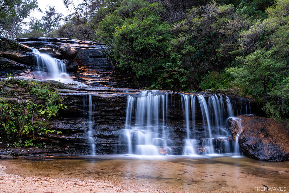
Wentworth Falls, with its towering multi-tiered drop and nearby Rocket Point lookout, is a clear standout. Not far away, the Valley of the Waters track leads to a series of beautiful falls including Empress, Sylvia, and Lodore.
Leura is full of quieter trails leading to scenic spots like Bridal Veil Falls, Leura Cascades, and the tranquil Pool of Siloam, while Katoomba Falls impresses with its size and location beside the famous clifftop walk.
This region is packed with well-maintained tracks, easy access, and big rewards—perfect if it’s your first time in the Blue Mountains or you’re short on time.
#17 Gordon Falls
- Region: Central Blue Mountains
- Closest Town: Leura
- Trail distance: 300m return
- Start & Finish: Gordon Falls Reserve Picnic Area
- Difficulty: Easy
- Nearby falls: Pool of Siloam
Gordon Falls is one of the easiest waterfalls to view in the Blue Mountains. From the Gordon Falls Reserve picnic area in Leura, it’s just a 300-metre return walk to the lookout, where you’ll get a full view of the waterfall plunging into the depths of the Jamison Valley.
The setting is stunning, especially with Mount Solitary and the Narrow Neck Plateau in the background.
While the top is easy to reach, getting to the base is a serious undertaking. The only way down is via a steep track that connects to Lindemans Pass — a rough, overgrown trail that runs between Leura and Sublime Point.
It’s not a route for beginners, but for experienced hikers, it offers a far more immersive way to explore this quieter side of Central Blue Mountains.
#16 Vera’s Grotto Falls
- Region: Central Blue Mountains
- Closest Town: Katoomba
- Trail distance: 2km return
- Start & Finish: Scenic World
- Difficulty: Moderate (steep descent)
- Nearby falls: Katoomba Falls, Katoomba Cascades, Witches Leap
If you’re doing the Katoomba Falls Round Walk, you can add a short detour down the Furber Steps to check out Vera’s Grotto Falls.
This lesser-known waterfall drops over a high sandstone ledge into a shady pocket of rainforest, surrounded by mossy boulders and ferns.
The short side track isn’t signposted but is easy enough to find just before the bottom section of Furber Steps.
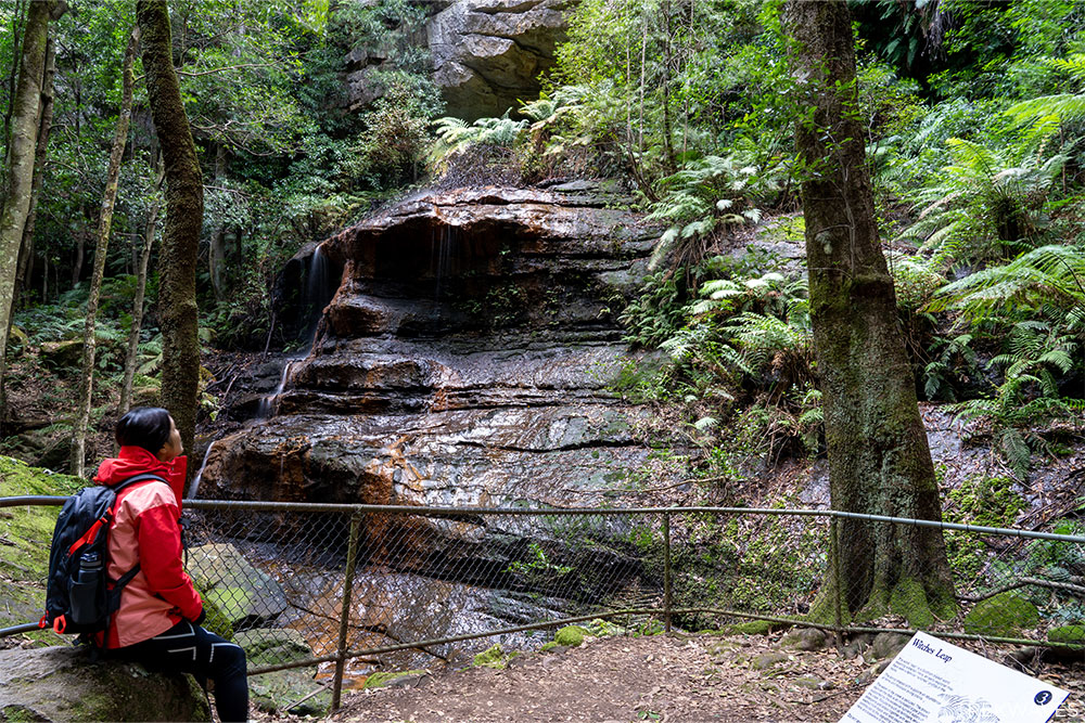
Just a little further up the Round Walk near the start of Furber Steps, you’ll find Witches Leap.
Its name is derived from early Scottish explorers who, upon observing the waterfall, were startled by a rock formation resembling a witch’s face.
The term “Leap” is a Scottish word for waterfall, commonly used in naming waterfalls in the Blue Mountains.
#15 Rainbow Falls
- Region: Central Blue Mountains
- Closest Town: Katoomba
- Trail distance: 1.3 km return
- Start & Finish: End of First Ave
- Difficulty: Easy / Moderate
Rainbow Falls is a lesser-known waterfall located at the northern part of Katoomba—only about 1.3 km return from the trailhead, making it a very short side trip that’s worth the detour if you’re in the area.
The path down is a bit rough—overgrown, slippery, and loosely defined. But don’t let that put you off.
The falls themselves are charming, with water flowing gently over smooth rocks, wide enough to sparkle with a rainbow in the right light.
Its off-the-beaten-path location means Rainbow Falls often feels like your own private waterfall. If you’re in Katoomba and want a quick stop away from the usual views, this one’s worth adding to your route.
#14 Linda Falls
- Region: Central Blue Mountains
- Closest Town: Leura
- Trail distance: 1.2km return
- Start & Finish: Echo Tree Lookout
- Difficulty: Moderate (steep descent)
- Nearby falls: Lila Falls, Leura Falls, Leura Cascades, Marguerite Cascades, Bridal Veil Falls
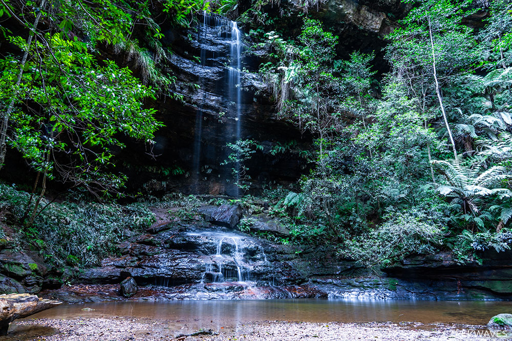
Hidden deep in the rainforest below Leura, Linda Falls is a quiet, fern-lined waterfall that’s well worth the effort to reach. The most direct way to get there is by starting at Echo Tree Lookout and taking the Fern Bower Track, which winds steeply down into the valley.
Another great option is to begin your hike at Leura Cascades and descend via the Amphitheatre Track, which adds a few more gorgeous waterfalls to your journey before linking up with the track to Linda Falls.
Rather than treating it as a one-way trip, I’d suggest turning it into a full loop: continue through the Leura Forest along Dardanelles Pass, climb the Giant Stairway beside the Three Sisters, and return via the clifftop views of the Prince Henry Cliff Walk.
#13 Pool of Siloam
- Region: Central Blue Mountains
- Closest Town: Leura
- Trail distance: 1.6km return
- Start & Finish: Gordon Falls Reserve
- Difficulty: Easy / Moderate
- Nearby falls: Gordon Falls
Pool of Siloam is a charming rainforest gem just below Leura’s Gordon Falls Reserve. It’s only a 1.6 km return track that starts at the picnic area and winds down a leafy path lined with stone steps and handrails.
Once you arrive, you’ll find a mossy, fern-framed cascade spilling into a shallow sandy pool—perfect for a relaxing break or splashing around in warm weather.
If you’re up for it, continue past the pool to Golf Links Lookout. From there, you’ll get expansive views across the Jamison Valley to iconic formations like Mount Solitary and the Three Sisters.
The trail is well-maintained with steps and is suitable for most fitness levels—just expect some mild steep sections on the way back up.
#12 Bonnie Doon Falls (Ethel Falls)
- Region: Central Blue Mountains
- Closest Town: Katoomba
- Trail distance: 1.8km return
- Start & Finish: End of Stuarts Rd
- Difficulty: Moderate
Bonnie Doon Falls — also known as Ethel Falls — is a unique waterfall located inside Nellies Glen, right off the Six Foot Track near Katoomba.
The short return walk starts at the end of Stuarts Road and descends through beautiful Boonie Doon Reserve, following a well-formed section of the historic trail.
What sets this one apart is the small cave behind the waterfall, letting you walk inside and view the cascade from behind the flow.
The trail to the base of the falls is not officially signposted, and includes some steep, slippery sections with loose rocks and roots.
#11 Water Nymphs Dell
- Region: Central Blue Mountains
- Closest Town: Wentworth Falls
- Trail distance: 1.4km return
- Start & Finish: Glenview Rd
- Difficulty: Moderate
If you’re looking for a short, quiet escape near Wentworth Falls, Water Nymphs Dell is a great little pocket of rainforest that often flies under the radar.
The trail descends into a quiet, mossy gully with a small waterfall pouring over a sandstone ledge into a shaded pool.
There’s even a bench in front of the waterfall — perfect for a sit-down surrounded by dripping cliffs and rainforest vibes.
At night, the gully’s walls come alive with glow worms, making Water Nymphs Dell one of the best and easiest places in the Blue Mountains to see these tiny lights.
#10 Minnehaha Falls
- Region: Central Blue Mountains
- Closest Town: Katoomba
- Trail distance: 2.3km return
- Start & Finish: Minnehaha Falls Reserve
- Difficulty: Moderate
- Trail Guide: Minnehaha Falls: Best Swimming Spot in Blue Mountains?
- Trail Video: Click here to watch on YouTube
Minnehaha Falls is a standout spot just north of Katoomba, along Yosemite Creek with a stunning waterfall and inviting pool—perfect for a quick dip in summer.
The trail starts at Minni‑Ha‑Ha Road car park and follows Yosemite Creek through native bush, with a few gentle cascades along the way, before descending steeper to the base of the falls.

The waterfall drops around 20m into a stunning swimming hole — perfect for a refreshing dip or a picnic. There’s even a rope swing and opportunities to jump from low cliffs when conditions are safe.
For a peaceful experience, go early. By mid-morning in summer, crowds and full car parks are common.

#9 Leura Cascades
- Region: Central Blue Mountains
- Closest Town: Leura
- Trail distance: 1.8km loop from Echo Tree Lookout
- Start & Finish: Echo Tree Lookout (or Leura Cascades Reserve)
- Nearby falls: Lila Falls, Linda Falls, Leura Falls, Marguerite Cascades, Bridal Veil Falls
- Difficulty: Easy / Moderate
- Trail Video: Click here to watch on YouTube
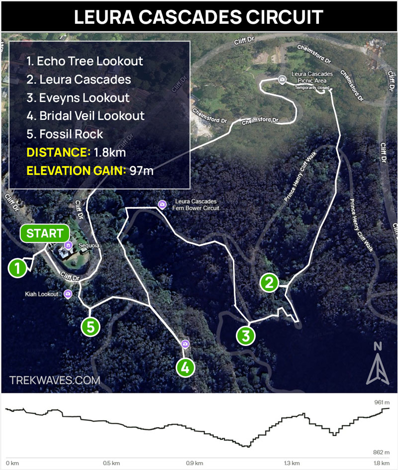
Leura Cascades sits in the heart of Central Blue Mountains, just a short, easy 1.8 km loop that starts and ends at Echo Tree Lookout in Leura.
The trail gently descends through lush bushland, crossing shaded creekbeds before revealing a series of beautiful cascades flowing over smooth sandstone steps
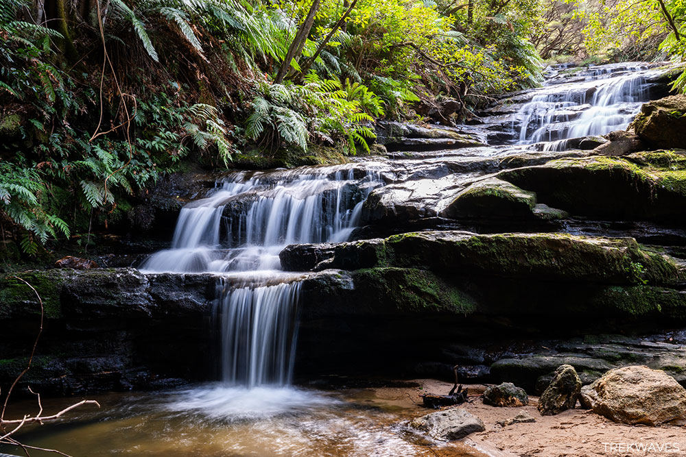
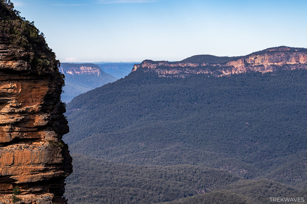
You’ll pass old boardwalks and stairs as the route winds through a fern-draped gully, eventually reaching the main cascade and then looping back via Bridal Veil Lookout with cliff-edge views across the Jamison Valley.
This charming walk takes about 1 hour and is ideal for anyone wanting a waterfall experience without diving into a full-day hike.
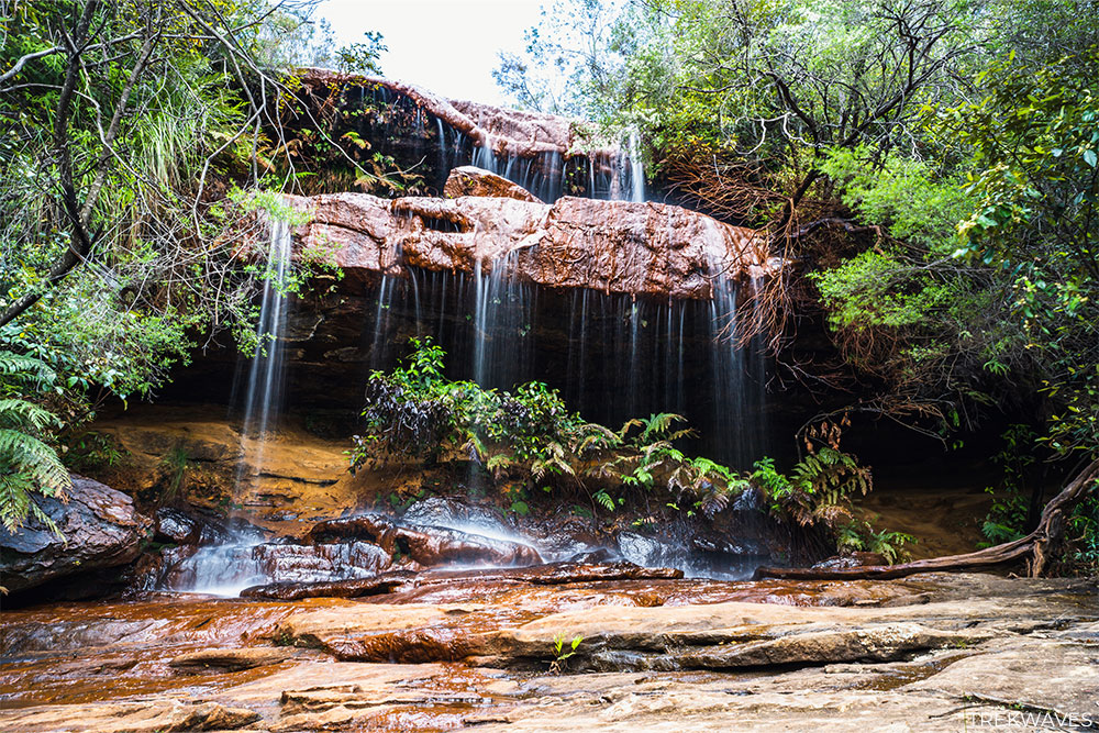
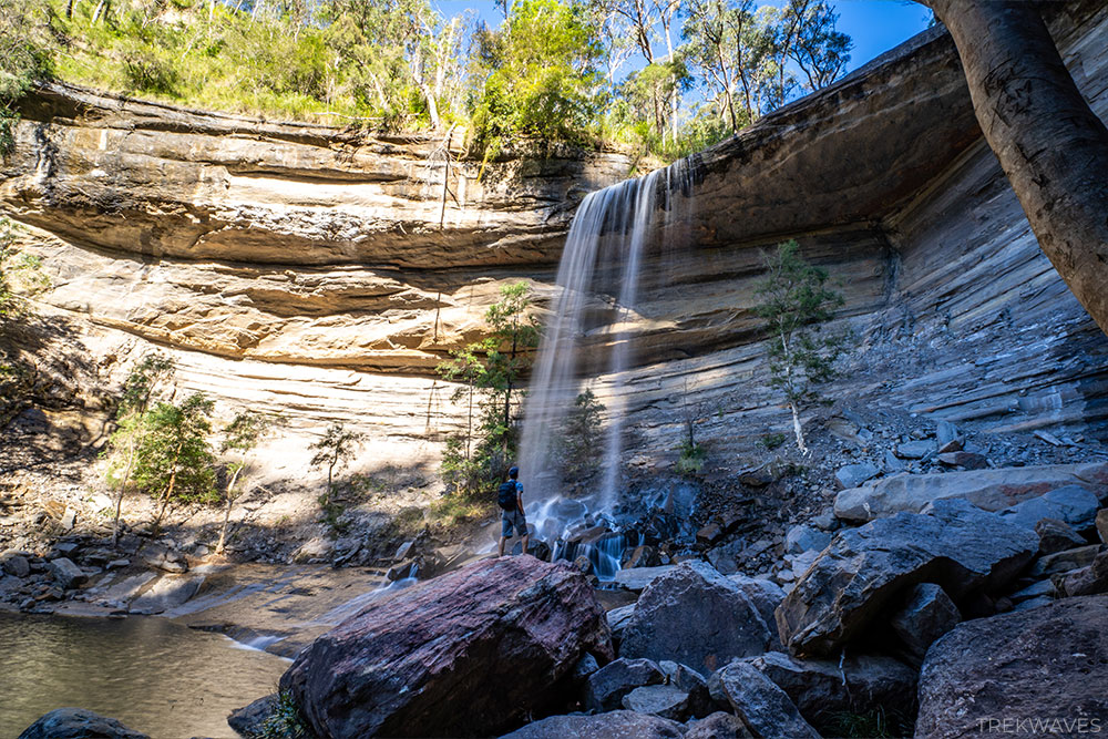
#8 Bridal Veil Falls
- Region: Central Blue Mountains
- Closest Town: Leura
- Trail distance: 1.5km return
- Start & Finish: Echo Tree Lookout (or Leura Cascades Reserve)
- Nearby falls: Lila Falls, Linda Falls, Marguerite Cascades, Leura Cascades, Leura Falls
- Difficulty: Moderate (steep descent)
Bridal Veil Falls lies just downstream from the more popular Leura Cascades. To reach its base, follow the same trail from Echo Tree Lookout, heading through the gully past Leura Cascades and Evelyns Lookout.
For the full view of the waterfall, you’ll need to continue a few hundred metres further along the Amphitheatre Track, descending past Evelyns Lookout until you reach the falls.
If you simply want a great vantage point without the extra descent, head to Bridal Veil View Lookout—a short, easily accessible offshoot from the Grand Cliff Top Walk.
This lookout offers a sweeping top-down view of the waterfall and the Jamison Valley beyond.
#7 Leura Falls
- Region: Central Blue Mountains
- Closest Town: Leura
- Trail distance: 1.8km return
- Start & Finish: Echo Tree Lookout
- Nearby falls: Lila Falls, Linda Falls, Leura Cascades, Marguerite Cascades, Bridal Veil Falls
- Difficulty: Moderate (steep descent)
The easiest to reach the base of Leura Falls is to start at Echo Tree Lookout and take the Fern Bower Track down through rainforest, passing Lila and Linda Falls on the way.
This steep descent leads down past Lila Falls, then to Linda Falls, and eventually brings you to an unmarked junction where you need to follow Lindemans Pass trail for around 300m.
The main drop — about 30 m — cascades into a shaded amphitheatre surrounded by towering cliffs.
This hidden gem rarely sees crowds—and the rainforest setting makes the journey feel like a classic Blue Mountains adventure.
#6 Katoomba Falls & Katoomba Cascades
- Region: Central Blue Mountains
- Closest Town: Katoomba
- Start & Finish: Scenic World
- Difficulty: Easy / Moderate
- Nearby falls: Vera’s Grotto Falls, Witches Leap
- Trail Guide: Katoomba Falls Round Walk Guide
- Trail Video: Click here to watch on YouTube
Katoomba Falls is the biggest and most popular waterfall in Katoomba, plunging in segmented tiers from the Kedumba River into the Jamison Valley.
To experience it from every angle, start at Scenic World and follow the Katoomba Falls Round Walk — a 2–3 km loop that takes you past multiple lookouts, including Vaniman’s Lookout, Juliet’s Balcony and Rainforest Lookout.
If you’d rather skip the steep return climb, the Scenic Railway offers an easy way back to the top. Make sure to take the short detour onto the Underfalls Walk, where you can stand almost level with the falls and feel the spray on a good flow day.
If you’re after a great view with minimal effort, simply head to Katoomba Falls Lookout, which is just a short stroll from the carpark and gives a fantastic perspective from the top of the cliffs.
After enjoying the main falls, it’s worth heading a few hundred metres further to check out Katoomba Cascades.
You can get there easily from the Round Walk by following the Prince Henry Cliff Walk. If you’ve got a Scenic World day pass, hop on the Scenic Skyway—the cascades are just a few minutes north from the other side.
#5 Asmodeus Pool & Flora’s Bath
- Region: Central Blue Mountains
- Closest Town: Wentworh Falls
- Start & Finish: Conservation Hut (Fletcher’s Street)
- Difficulty: Easy / Moderate
- Nearby falls: Isobel Falls, Empress Falls, Sylvia Falls, Edith Falls, Flat Rock Falls
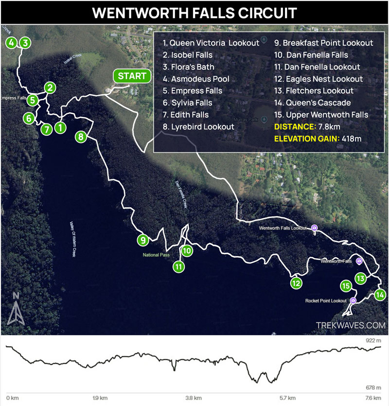
These two hidden waterfalls—Flora’s Bath (easy access) and Asmodeus Pool (a bit of a scramble)—sit within 50 m of each other in Lillian’s Glen, along the Nature Track that links to the Valley of the Waters main route .
Flora’s Bath is the easier of the two to reach: a short walk across stepping stones leads to a charming shallow pool framed by sandstone and ferns.
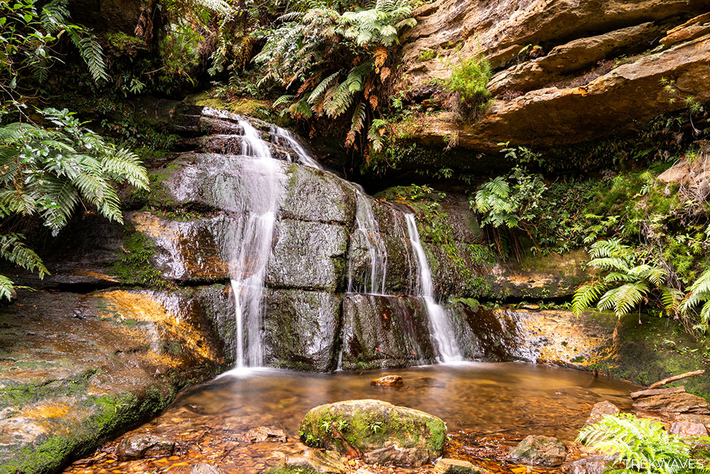
Just upstream, Asmodeus Pool requires a bit more effort—a short scramble over boulders and through low water, but it leads into a narrow slot canyon with a waterfall spilling into a deep, shady pool. It’s one of the most atmospheric swimming holes in the mountains.
If you’re already taking in the bigger Valley of the Waters waterfalls, this detour offers an unforgettable taste of wild swimming and a unique contrast to the more crowded falls along the main track.
#4 Queen’s Cascade
- Region: Central Blue Mountains
- Closest Town: Wentworh Falls
- Start & Finish: Wentworth Falls Picnic Area
- Difficulty: Easy
- Nearby falls: Weeping Rock, Wentworth Falls
Queen’s Cascade is the first waterfall you’ll come across on the way down to Wentworth Falls, flowing gently over smooth sandstone into a wide, shallow pool with a sandy base.
It’s set along Jamison Creek, and surrounded by lush greenery and forest, making it a peaceful and scenic stop early in the walk.
There’s a set of stepping stones crossing the creek here, and the sound of the cascading water sets the mood for the rest of the hike.
It’s a lovely spot to take a break and enjoy the surroundings before heading down to the main falls.
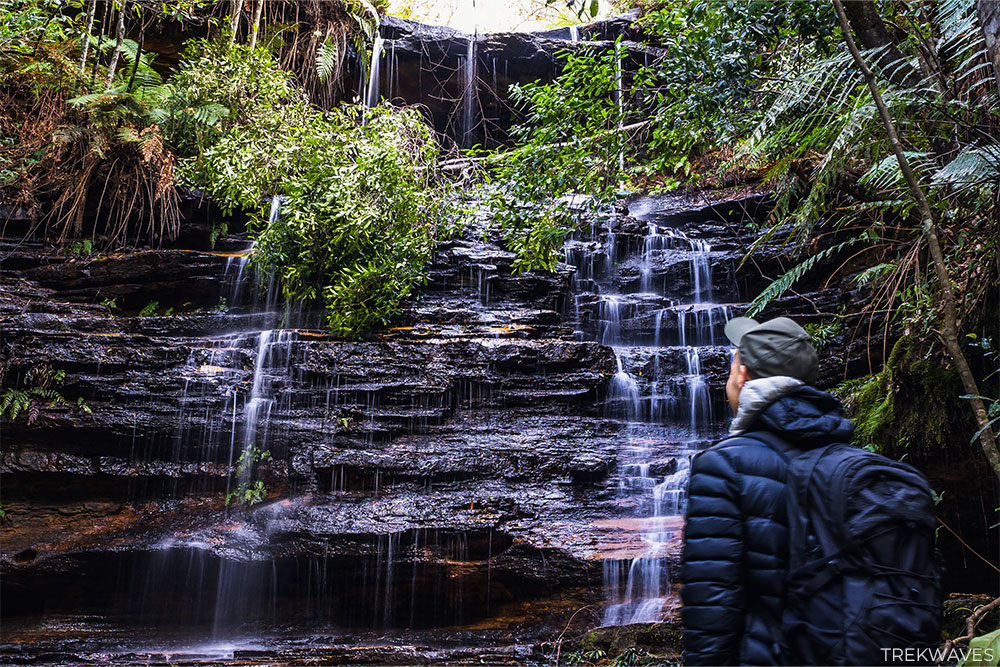
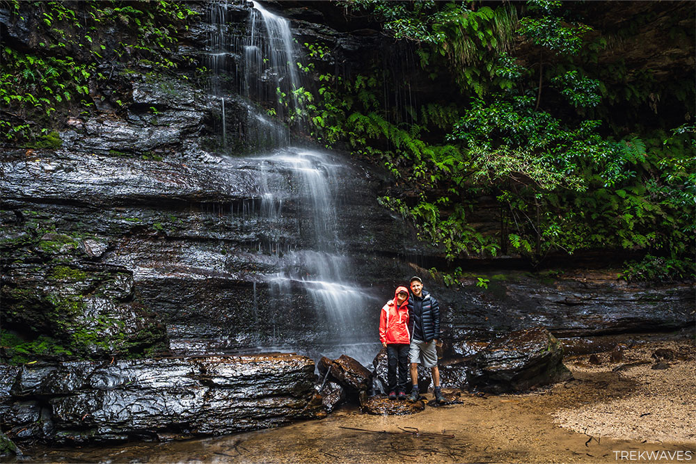
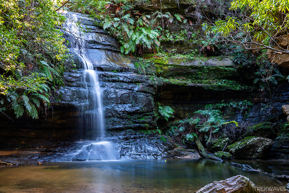
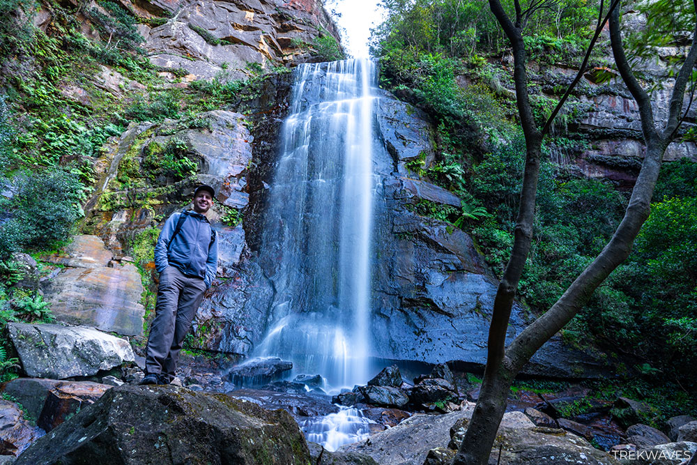
#3 Empress Falls
- Region: Central Blue Mountains
- Closest Town: Wentworh Falls
- Start & Finish: Conservation Hut (Fletcher’s Street)
- Difficulty: Moderate (steep descent)
- Nearby falls: Sylvia Falls, Edith Falls, Isobel Falls, Flat Rock Falls, Asmodeus Pool, Flora’s Bath
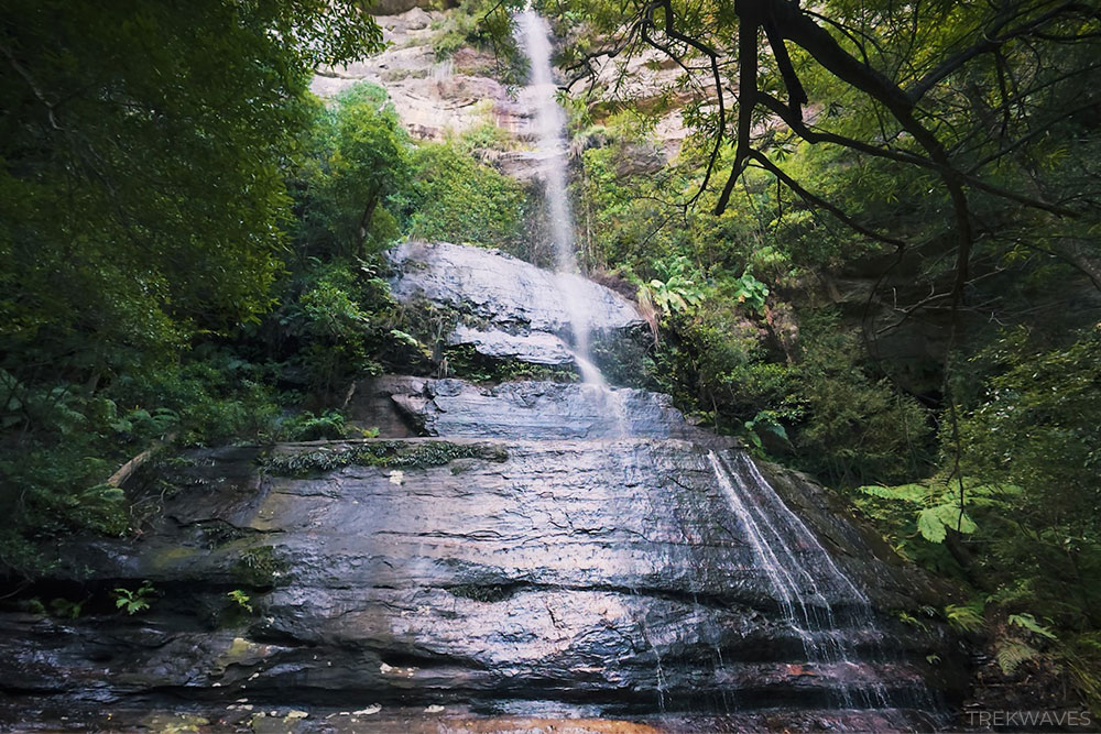
Empress Falls is a standout waterfall in the Valley of the Waters area near Wentworth Falls, and it’s definitely one of my personal favourites.
It’s about 35 meters high and drops into a deep, shaded pool surrounded by ferns, trees and large boulders.
The walk to get there is mostly easy to moderate, with some stairs and a few steeper parts, but the path is well-maintained.
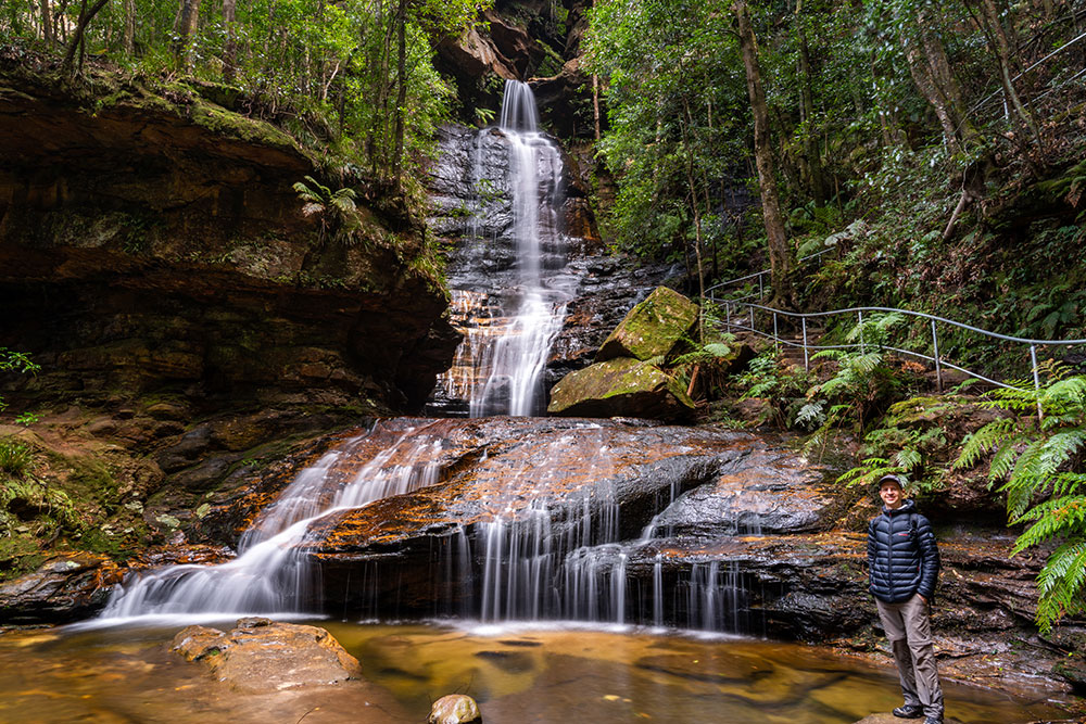
If you’re feeling adventurous, there are also guided canyoning tours where you can abseil down the waterfall— a totally different way to experience Empress Falls. But even just seeing it from the bottom is worth the trip.
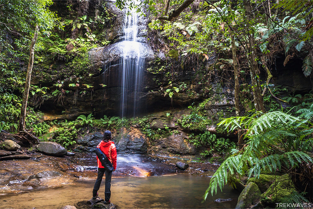
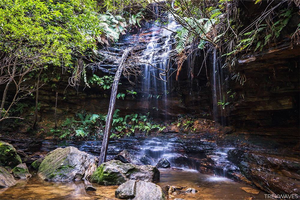
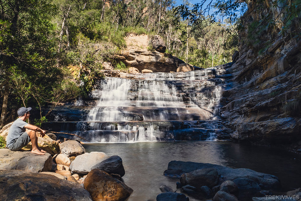
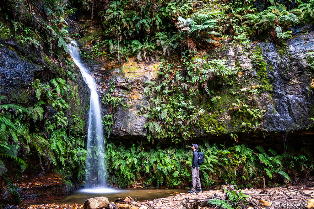
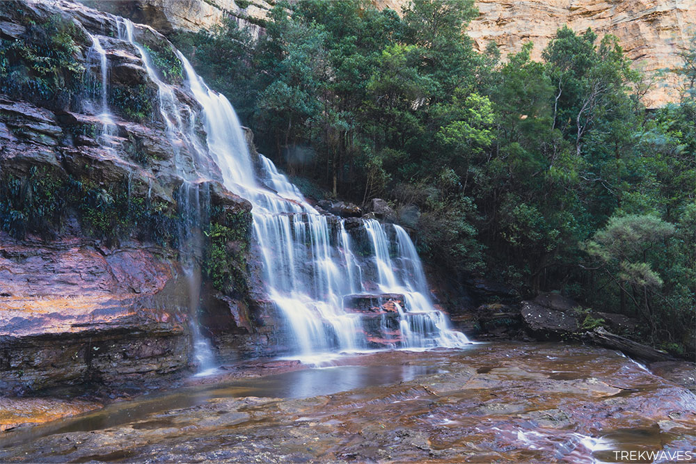
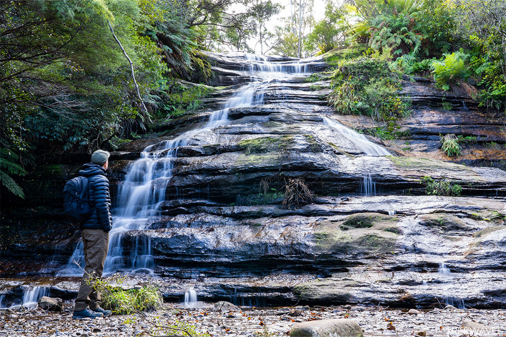
#2 Sylvia Falls
- Region: Central Blue Mountains
- Closest Town: Wentworh Falls
- Start & Finish: Conservation Hut (Fletcher’s Street)
- Difficulty: Moderate (steep descent)
- Nearby falls: Empress Falls, Edith Falls, Isobel Falls, Flat Rock Falls, Asmodeus Pool, Flora’s Bath
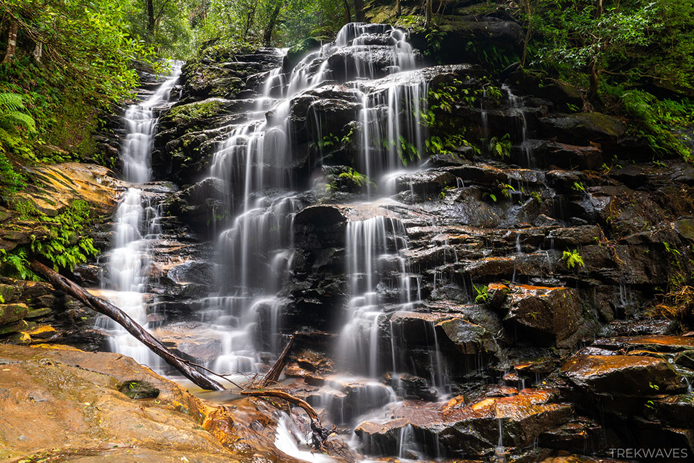
Sylvia Falls sits just below Empress Falls on the popular Valley of the Waters trail and is easily one of the most photogenic waterfalls in the Blue Mountains.
It’s a multi-tiered cascade that drops gracefully over several sandstone shelves, framed by dense ferns and mossy rock walls.
When the light hits the water just right, it creates an almost ethereal shimmer as the falls plunge into the forest below.
Located just below the more well-known Sylvia Falls, Edith Falls is a charming little hideaway on the Valley of the Waters track.
The stepping stones across the creek lead right to the base of the falls, offering a front-row seat to the cascade.
Edith Falls is the final waterfall you can currently visit along the Valley of the Waters trail, as the track beyond this point remains closed at the time of writing.
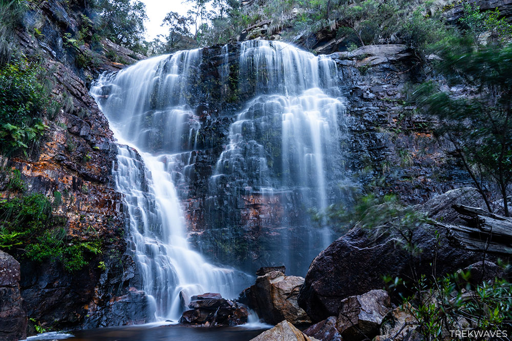
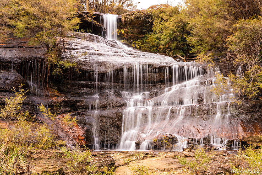
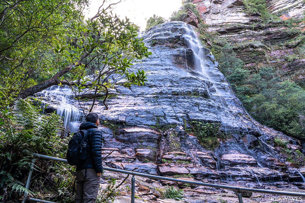
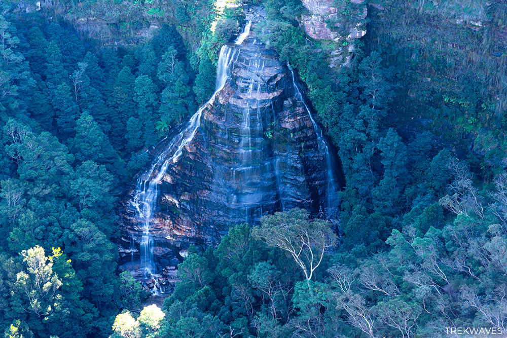
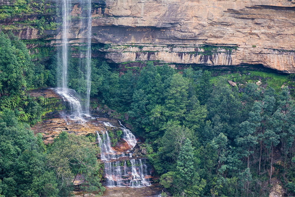
#1 Wentworth Falls
- Region: Central Blue Mountains
- Closest Town: Wentworh Falls
- Start & Finish: Wentworth Falls Picnic Area
- Difficulty: Moderate (steep descent)
- Nearby falls: Queen’s Cascade, Weeping Rock
There’s no doubt about it — Wentworth Falls is the crown jewel of the Blue Mountains. It’s the tallest and most iconic waterfall in the region, and its multi-tiered drop down the sandstone cliffs is impressive from just about any angle.
Even after seeing dozens of waterfalls across the region, this one still leaves a lasting impression.
Right now, you can only access the Upper Falls section. The full trail to the base via National Pass and Wentworth Pass is still closed due to safety issues, which is a real shame, because the view from below is incredible.
That said, there are still plenty of rewarding vantage points if you’re keen to take it in.
Rocket Point Lookout offers a brilliant top-down perspective with hardly any foot traffic, and Eagles Nest Lookout and Fletchers Lookout are both great for a front-on view of the falls without needing to hike too far.
Summary
And that’s a wrap on 40 incredible waterfalls across the Blue Mountains!
Whether you’re new to the area or a regular weekend wanderer, I hope this guide helps you uncover a few new favourites — or inspires your next adventure.
If you’ve got a favourite waterfall that didn’t make the list, I’d love to hear about it! Drop a comment below and share your top picks — or let me know which of these waterfalls you’re most excited to visit next.
Happy exploring!
Found it Helpful? Pin it For Later!